Approximate Location Map
Large Map »
Latitude: 53.8116 / 53°48'41"N
Longitude: -1.552 / 1°33'7"W
OS Eastings: 429597
OS Northings: 435131
OS Grid: SE295351
Mapcode National: GBR BHF.6F
Mapcode Global: WHC9D.4G78
Plus Code: 9C5WRC6X+M6
Entry Name: Churchyard wall with railings and gate piers to south and steps to north
Listing Date: 11 September 1996
Last Amended: 11 September 1997
Grade: II
Source: Historic England
Source ID: 1256145
English Heritage Legacy ID: 465220
ID on this website: 101256145
Location: St Mark's Church, Woodhouse Carr, Leeds, West Yorkshire, LS6
County: Leeds
Electoral Ward/Division: Hyde Park and Woodhouse
Parish: Non Civil Parish
Built-Up Area: Leeds
Traditional County: Yorkshire
Lieutenancy Area (Ceremonial County): West Yorkshire
Church of England Parish: Woodhouse and Wrangthorn
Church of England Diocese: Leeds
Tagged with: Churchyard wall
This list entry was subject to a Minor Amendment on 12 July 2021 to reformat text to current standards
SE2935
714-1/24/1269
LEEDS
Woodhouse Carr
ST MARK'S ROAD (North side)
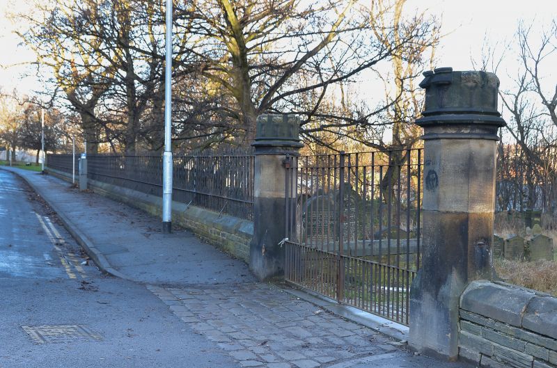
Churchyard wall with railings and gate piers to south and steps to north
GV
II
Wall enclosing churchyard, with gate piers, railings and steps. Probably c1825, damaged c1995. Coursed stone walls, ashlar piers, wrought-iron railings.
Walling: overall length approximately 450m, varied height, approximately 2m high increasing along north side and surmounted by railings along south (road) side, 2m section damaged by car crash. Steps on north side are stone, set into steep banking, dogleg form. Octagonal piers with battlemented capstones, railings with alternate straight and wavy pointed rails, chamfered coping to low stone wall which returns to form a flanking wall to the church approach for approx 4m. The churchyard gates and the north side steps are linked by a footpath which may pre-date the church. The area to north of the church was densely packed with back-to-back housing by the late C19.
Included for group value.
Listing NGR: SE2959735131
External links are from the relevant listing authority and, where applicable, Wikidata. Wikidata IDs may be related buildings as well as this specific building. If you want to add or update a link, you will need to do so by editing the Wikidata entry.


Other nearby listed buildings
