Approximate Location Map
Large Map »
Latitude: 53.7972 / 53°47'49"N
Longitude: -1.5542 / 1°33'15"W
OS Eastings: 429461
OS Northings: 433521
OS Grid: SE294335
Mapcode National: GBR BGL.QL
Mapcode Global: WHC9D.3T5D
Plus Code: 9C5WQCWW+V8
Entry Name: Numbers 2, 4 and 4A and Attached Railings
Listing Date: 5 August 1976
Last Amended: 11 September 1996
Grade: II
Source: Historic England
Source ID: 1256194
English Heritage Legacy ID: 465179
ID on this website: 101256194
Location: Leeds, West Yorkshire, LS1
County: Leeds
Electoral Ward/Division: City and Hunslet
Parish: Non Civil Parish
Built-Up Area: Leeds
Traditional County: Yorkshire
Lieutenancy Area (Ceremonial County): West Yorkshire
Church of England Parish: Leeds St George
Church of England Diocese: Leeds
Tagged with: Building
LEEDS
SE2933 QUEEN STREET
714-1/35/349 (East side)
05/08/76 Nos.2, 4 AND 4A
and attached railings
(Formerly Listed as:
QUEEN STREET
(East side)
Nos.2 AND 4)
(Formerly Listed as:
YORK PLACE
(South side)
Nos.26 AND 27)
GV II
Includes: No.27 YORK PLACE.
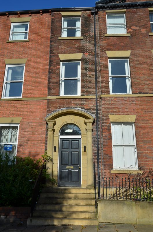
4 houses, now offices, with basement railings. Early C19 with
late C20 restoration. Red brick, Flemish bond. Corner site
with No.27 York Place on left return.
3 storeys and basement, 8 first-floor windows, the 5-window
block right stepped down slightly. 2 round-headed doorways
with fanlights and panelled doors, left door with overlight
probably an insertion. All sashes with glazing bars, flat
brick arches, stone sills, continuous 1st-floor sill band,
fielded-panel aprons to ground-floor windows. Restored eaves
band, brick stacks. Left return similar, 2-windows wide.
INTERIOR: not inspected.
Part of the development of the south side of York Place in
1834-1850, probably as private residences but the proximity of
mills and the railway resulted in their conversion to woollen
warehouses by 1886.
(Rapkin, J: Map of Leeds: 1850-; Insurance map of Leeds:
1886-).
Listing NGR: SE2946133521
External links are from the relevant listing authority and, where applicable, Wikidata. Wikidata IDs may be related buildings as well as this specific building. If you want to add or update a link, you will need to do so by editing the Wikidata entry.


Other nearby listed buildings
