Approximate Location Map
Large Map »
Latitude: 53.9568 / 53°57'24"N
Longitude: -1.0901 / 1°5'24"W
OS Eastings: 459803
OS Northings: 451570
OS Grid: SE598515
Mapcode National: GBR NQTP.SC
Mapcode Global: WHFC3.7T51
Plus Code: 9C5WXW45+PX
Entry Name: 112, Micklegate
Listing Date: 24 June 1983
Grade: II
Source: Historic England
Source ID: 1257301
English Heritage Legacy ID: 464047
ID on this website: 101257301
Location: York, North Yorkshire, YO1
County: York
Electoral Ward/Division: Micklegate
Parish: Non Civil Parish
Built-Up Area: York
Traditional County: Yorkshire
Lieutenancy Area (Ceremonial County): North Yorkshire
Church of England Parish: Micklegate Holy Trinity
Church of England Diocese: York
Tagged with: Building
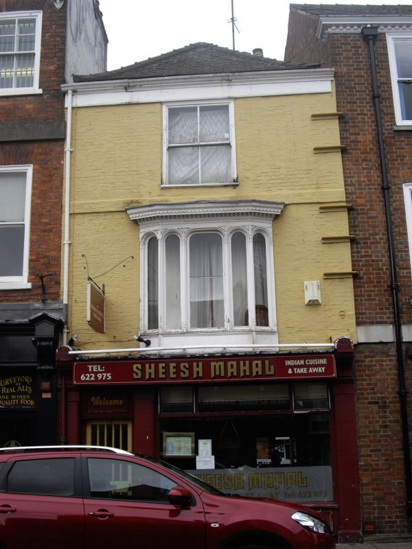
YORK
SE5951NE MICKLEGATE
1112-1/15/678 (North side)
24/06/83 No.112
GV II
House, now restaurant. Early C16, partly rebuilt and refronted
in 1745-48; refenestrated, including shopfronts, 1860-70.
Timber-framed, refronted in painted brick in Flemish bond;
timber eaves band and cornice to hipped slate roof with
scrolled corner brackets, with brick stacks.
EXTERIOR: 3-storey 1-window front. Shopfront of painted brick
antae with moulded imposts, coved fascia with flat capping
between grooved brackets crowned with semicircular gablets;
C20 glazed door to left of plate glass window over panelled
riser. On first floor, canted bay window of 5 arched lights on
colonnette shafts, over band of moulded roundels; moulded
frieze and dentilled and scalloped cornice. 4-pane sash window
on second floor. 3-course raised brick band at second floor
level.
INTERIOR: not inspected. RCHM record exposed timber-framing
with braced posts: original roof survives intact except for
the loss of the front truss when the roof was hipped in C18.
(City of York: RCHME: South-west of the Ouse: HMSO: 1972-:
92).
Listing NGR: SE5980351570
External links are from the relevant listing authority and, where applicable, Wikidata. Wikidata IDs may be related buildings as well as this specific building. If you want to add or update a link, you will need to do so by editing the Wikidata entry.


Other nearby listed buildings
