Approximate Location Map
Large Map »
Latitude: 50.9521 / 50°57'7"N
Longitude: -2.7142 / 2°42'51"W
OS Eastings: 349929
OS Northings: 117206
OS Grid: ST499172
Mapcode National: GBR MK.NB66
Mapcode Global: FRA 566L.GFL
Plus Code: 9C2VX72P+R8
Entry Name: The orangery and linking wing walling to the north-west corner of Montacute House
Listing Date: 19 April 1961
Grade: II
Source: Historic England
Source ID: 1262472
English Heritage Legacy ID: 434946
ID on this website: 101262472
Location: Montacute, Somerset, TA15
County: Somerset
District: South Somerset
Civil Parish: Montacute
Built-Up Area: Montacute
Traditional County: Somerset
Lieutenancy Area (Ceremonial County): Somerset
Tagged with: Orangery
ST4917
7/124
MONTACUTE CP
THE BOROUGH (North side, off)
The orangery and linking wing walling to the north-west corner of Montacute House
19.4.61
GV
II
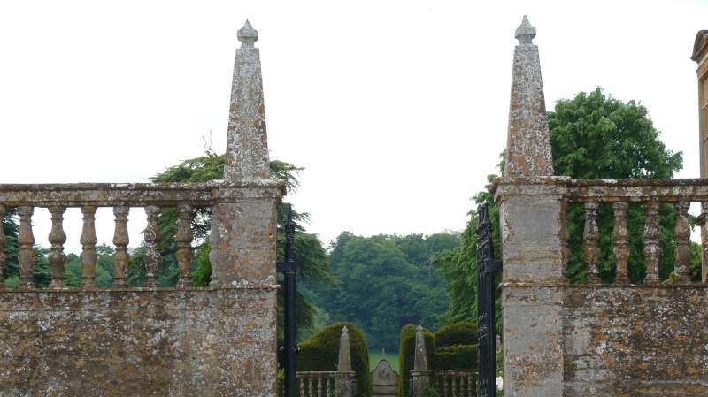
Orangery. 1848, possibly by Lewis Vulliamy. Ham stone ashiar; hipped leaded glass roof in small panes. Single-storey, seven bays. Plinth, Doric pilasters between bays and to corners, these all topped by obelisk finials over a quasi-cornice; forty-pane sash windows to all but the wider centre bay, which has a pair of glazed doors with twenty one panes each. Timber-frame internally. Undergoing restoration at time of inspection (September 1985).
Extending from south-east corner for about 6 metres to Montacute House (q.v) walling about 2.5m high, solid below and capped by turned balusters and moulded coping; central gateway with square piers having obelisk finials, with pair C19 cast iron gates. The whole adds to the setting of the House, and is part of the mid C19 reshaping of the grounds.
Listing NGR: ST4992917206
External links are from the relevant listing authority and, where applicable, Wikidata. Wikidata IDs may be related buildings as well as this specific building. If you want to add or update a link, you will need to do so by editing the Wikidata entry.


Other nearby listed buildings
