Approximate Location Map
Large Map »
Latitude: 51.3978 / 51°23'52"N
Longitude: 0.5391 / 0°32'20"E
OS Eastings: 576726
OS Northings: 169591
OS Grid: TQ767695
Mapcode National: GBR PPP.C3X
Mapcode Global: VHJLV.94B8
Plus Code: 9F329GXQ+4J
Entry Name: Bridge, with railings, stairs, abutment and lamps to north side of Central Avenue
Listing Date: 6 June 1984
Last Amended: 5 December 1996
Grade: II
Source: Historic England
Source ID: 1267800
English Heritage Legacy ID: 462579
ID on this website: 101267800
Location: Brompton, Medway, Kent, ME4
County: Medway
Electoral Ward/Division: River
Parish: Non Civil Parish
Built-Up Area: Gillingham
Traditional County: Kent
Lieutenancy Area (Ceremonial County): Kent
Church of England Parish: Gillingham St Mark
Church of England Diocese: Rochester
Tagged with: Bridge
This list entry was subject to a Minor Amendment on 03/06/2019
TQ7669NE
686-1/2/102
GILLINGHAM
Pembroke
LOWER EAST ROAD (south side)
Bridge, with railings, stairs, abutment and lamps to north side of Central Avenue
(Formerly listed as Bridge, with railings, stairs, abutment and lamps to south side of Central Avenue, LOWER EAST ROAD (south side))
(Previously Listed as: CENTRAL AVENUE Railings, stairs, abutment, lamps; Central Ave, Lower East Road & bridge Lower East Road)
(Previously Listed as: LOWER EAST ROAD Railings, stairs, abutment, lamps; Central Ave, Lower East Road & bridge Lower East Road)
06/06/84
GV
II
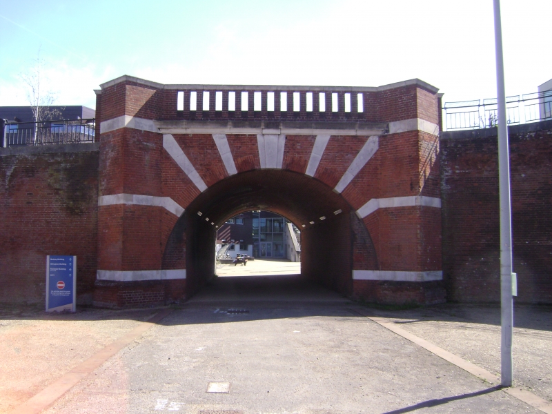
Railings, stairs, abutment, lamps and bridge. c1902 by Sir Henry Pilkington; rebuilt later C20. Red brick and Portland stone dressings, with cast-iron lamps. Retaining wall to south side of Drill Square with coped parapet, piers with segmental-gabled caps and eleven Art Nouveau-style foliate lamp stands to square lamps; five sets of steps down to Drill Square with coped parapets and round-arched openings, with cast-iron railings with fluted segmental head standards. Railings extend over bridge down both sides of Upper East Road. At east end, the bridge has a moulded cornice with simple brick balusters to balustrade over, round archway with radiating stone alternate voussoirs, and diagonally-set flanking buttresses.
HISTORY: part of a complete early C20 barracks, with the Captain's House, Mess Block (Central Ave.), barracks (Pasley Rd) and ancillary buildings (qqv).
Listing NGR: TQ7672669591
External links are from the relevant listing authority and, where applicable, Wikidata. Wikidata IDs may be related buildings as well as this specific building. If you want to add or update a link, you will need to do so by editing the Wikidata entry.


Other nearby listed buildings
