Approximate Location Map
Large Map »
Latitude: 51.5847 / 51°35'4"N
Longitude: -2.0995 / 2°5'58"W
OS Eastings: 393202
OS Northings: 187319
OS Grid: ST932873
Mapcode National: GBR 2QZ.Q02
Mapcode Global: VH95S.KFFJ
Plus Code: 9C3VHWM2+V6
Entry Name: 54, Gloucester Street
Listing Date: 1 July 1976
Last Amended: 19 July 1996
Grade: II
Source: Historic England
Source ID: 1269426
English Heritage Legacy ID: 460796
ID on this website: 101269426
Location: Malmesbury, Wiltshire, SN16
County: Wiltshire
Civil Parish: Malmesbury
Built-Up Area: Malmesbury
Traditional County: Wiltshire
Lieutenancy Area (Ceremonial County): Wiltshire
Church of England Parish: Malmesbury and Brokenborough
Church of England Diocese: Bristol
Tagged with: Building
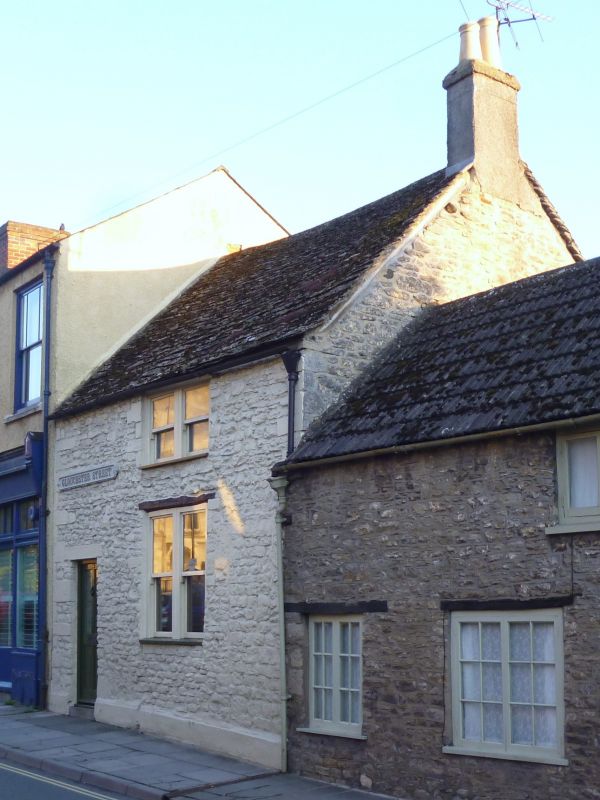
MALMESBURY
ST9387 GLOUCESTER STREET
758-1/4/132 (South West side)
01/07/76 No.54
(Formerly Listed as:
GLOUCESTER STREET
(South West side)
Nos.54 AND 56)
GV II
House. C18 with C20 rear extension. Limestone rubble and
dressings, brick right-hand gable stack and a stone slate
roof. Single room plan.
2 storeys and basement; 1-window range. Large irregular quoins
to the left and on the right above eaves of No.56; a left-hand
doorway with 4-panel C20 door, large former shop window with
glazing bars and a low first-floor casement beneath the eaves.
Rear dormer.
INTERIOR: details include a right-hand basement
through-passage, winder stair to the left of the fireplace,
stone from the basement but partly removed, windows with
splayed reveals, and collar truss roof; the basement has a
blocked window facing into the street, and a large fireplace
with splayed reveals and bressumer.
SUBSIDIARY FEATURES: mid C19 cast-iron name plate above the
doorway inscribed GLOUCESTER STREET.
HISTORICAL NOTE: the level of Gloucester Street may have been
approx 1-2m lower than now, to allow for the basement window.
A cut and cover drain ran down to the river.
Listing NGR: ST9320387315
External links are from the relevant listing authority and, where applicable, Wikidata. Wikidata IDs may be related buildings as well as this specific building. If you want to add or update a link, you will need to do so by editing the Wikidata entry.


Other nearby listed buildings
