Latitude: 52.2439 / 52°14'38"N
Longitude: 0.7127 / 0°42'45"E
OS Eastings: 585298
OS Northings: 264104
OS Grid: TL852641
Mapcode National: GBR QF0.70K
Mapcode Global: VHKD4.9VMP
Plus Code: 9F426PV7+H3
Entry Name: 83, Whiting Street
Listing Date: 7 August 1952
Grade: II
Source: Historic England
Source ID: 1271636
English Heritage Legacy ID: 467840
ID on this website: 101271636
Location: Bury St Edmunds, West Suffolk, IP33
County: Suffolk
District: West Suffolk
Civil Parish: Bury St Edmunds
Built-Up Area: Bury St Edmunds
Traditional County: Suffolk
Lieutenancy Area (Ceremonial County): Suffolk
Church of England Parish: Bury St Edmunds St Mary
Church of England Diocese: St.Edmundsbury and Ipswich
Tagged with: Building
BURY ST EDMUNDS
TL8564SW WHITING STREET 639-1/14/728 (West side) 07/08/52 No.83
GV II
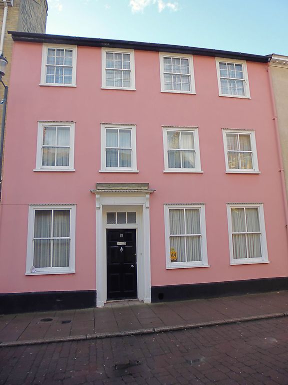
House. Early C16 and early C17, fronted and raised in the C18. Timber-framed and rendered; slate roof. A 2-bay front range, originally jettied, and a long rear range in 2 phases with an internal chimney-stack linking front and rear. EXTERIOR: 3 storeys and cellars; 3 window range: all sashes in flush cased frames, with a single vertical bar to lights on the ground and 1st storey and with 12 panes on the 2nd storey. The off-centre door with 6 raised fielded panels has a plain architrave and a flat pediment supported by solid console brackets. The rear range is in 5 bays, with the 2-and-a-half jettied bays to the east now underbuilt in brick. The remains of good external studding now rendered; evidence of former ovolo-moulded mullioned windows along the south wall. The roof, raised in the C19, is slated. INTERIOR: both ranges have cellars: that below the front range rendered, with several wide brick-lined niches, apparently contemporary with the frame above. The ground storey of the 2-bay front range is divided by an early C18 panelled partition into 2 rooms, but was originally one. Both rooms have main beams with multiple roll-mouldings, curved stops, and evidence for an underbuilt jetty. The remains of re-set Jacobean panelling in both end walls. Paintings, thought to date from the early C16, were discovered during restoration in 1991 behind the panelling on the north wall. The painting covers both plaster and studs of what is the shared partition wall with No.84 (qv) with a formalised repetitive pattern of fruit, leaves and diagonal bands of lettering, now illegible. All 3 ground storey windows have boxed pull-up shutters in good condition. The chimney-stack on the rear wall of the north bay has a timber lintel with multiple roll mouldings and leaf stops; red ochre colouring and lining over the brickwork. On the upper storey the partition wall has studding exposed with a single long brace at one end. The end wall on the north has only the main components of the frame and was built up against a pre-existent building. The top storey is a C19 addition. A hall at the rear is paved with stone flags and leads to the 2-storey timber-framed range at the back. The rear range is in 5 bays, the 3 early C16
eastern bays originally jettied, the other 2 bays an unjettied C17 addition. The older bays have exposed studding along the north wall, heavy unchamfered joists set flat, and main posts with the jowls hacked off. The internal chimney-stack which links the 2 ranges has a large open fireplace on this side with a plain chamfered lintel, cut-off stops, traces of red ochre colouring on the brickwork and 2 pointed niches, one set very high. Along the north wall an inserted 5-light window with roll and cavetto mouldings to the mullions and narrow iron bars between. Partitions throughout the whole rear range were removed or resited in the mid C19, when the roof was raised and slated at a shallow pitch. From 1758, the first year of surviving rating assessments, until his death in 1762, this house was owned and occupied by Thomas Warren senior, the surveyor who produced a fine printed map of the town in 1747. He was succeeded by his son Thomas, also a cartographer,who lived in the house until his death in 1805.
Listing NGR: TL8529864104
External links are from the relevant listing authority and, where applicable, Wikidata. Wikidata IDs may be related buildings as well as this specific building. If you want to add or update a link, you will need to do so by editing the Wikidata entry.


Other nearby listed buildings