Latitude: 52.1928 / 52°11'34"N
Longitude: -1.7071 / 1°42'25"W
OS Eastings: 420115
OS Northings: 254994
OS Grid: SP201549
Mapcode National: GBR 4LT.F75
Mapcode Global: VHBY0.C4CT
Plus Code: 9C4W57VV+44
Entry Name: 44 and 44A, Wood Street
Listing Date: 9 February 1972
Last Amended: 4 April 1994
Grade: II
Source: Historic England
Source ID: 1279695
English Heritage Legacy ID: 366464
ID on this website: 101279695
Location: Stratford-upon-Avon, Stratford-on-Avon, Warwickshire, CV37
County: Warwickshire
District: Stratford-on-Avon
Civil Parish: Stratford-upon-Avon
Built-Up Area: Stratford-upon-Avon
Traditional County: Warwickshire
Lieutenancy Area (Ceremonial County): Warwickshire
Church of England Parish: Stratford on Avon Holy Trinity
Church of England Diocese: Coventry
Tagged with: Building
STRATFORD-UPON-AVON
SP2054NW WOOD STREET 604-1/10/263 (North side) 09/02/72 Nos.44 AND 44A (Formerly Listed as: STRATFORD ON AVON WOOD STREET (North side) Nos.42 AND 43)
GV II
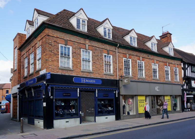
Town house now shops/offices. c1760; altered and extended 1930s. Brick with buff headers and ashlar dressings; hipped tile roof. Georgian style. 2 storeys with attic; 8-window range, originally 5-window range extended to left. 1st floor brick lintel bands and top timber cornice; mid to late C20 shop fronts. 1st floor has windows with moulded sills, and rubbed brick flat arches with keys over 12-pane horned sashes with wide frames; 5 gabled dormers with 2-light casements; 2 with leaded and 3 with small-paned glazing. Similar 1930s range to Henley Street not included. (Bearman R: Stratford-upon-Avon: A History of its Streets and Buildings: Nelson: 1988-: 62).
Listing NGR: SP2011554994
External links are from the relevant listing authority and, where applicable, Wikidata. Wikidata IDs may be related buildings as well as this specific building. If you want to add or update a link, you will need to do so by editing the Wikidata entry.


Other nearby listed buildings