Approximate Location Map
Large Map »
Latitude: 53.1438 / 53°8'37"N
Longitude: -1.1918 / 1°11'30"W
OS Eastings: 454153
OS Northings: 361049
OS Grid: SK541610
Mapcode National: GBR 8F5.ZDB
Mapcode Global: WHDFZ.N7NP
Plus Code: 9C5W4RV5+G7
Entry Name: Boundary Wall and Gates at Bridge Street Methodist Church
Listing Date: 21 March 1994
Grade: II
Source: Historic England
Source ID: 1279884
English Heritage Legacy ID: 391671
ID on this website: 101279884
Location: Mansfield, Nottinghamshire, NG18
County: Nottinghamshire
District: Mansfield
Electoral Ward/Division: Portland
Parish: Non Civil Parish
Built-Up Area: Mansfield
Traditional County: Nottinghamshire
Lieutenancy Area (Ceremonial County): Nottinghamshire
Church of England Parish: Mansfield St Peter and St Paul
Church of England Diocese: Southwell and Nottingham
Tagged with: Wall
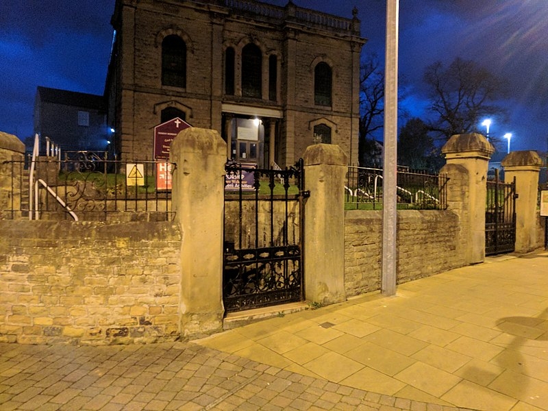
MANSFIELD
SK5461 BRIDGE STREET
924-1/6/17 (North side)
Boundary wall and gates at Bridge
Street Methodist Church
GV II
Boundary wall and gates. 1864, with railing renewed mid C20.
Coursed rubble wall with chamfered ashlar coping. 2 square
ashlar main gate piers with truncated pyramidal caps and
cast-iron gates. To left, side gate with 2 plain square piers
with chamfered tops and cast-iron gate. Wall approx 75m long.
Included for group value.
Listing NGR: SK5415361049
External links are from the relevant listing authority and, where applicable, Wikidata. Wikidata IDs may be related buildings as well as this specific building. If you want to add or update a link, you will need to do so by editing the Wikidata entry.


Other nearby listed buildings
