Approximate Location Map
Large Map »
Latitude: 54.9231 / 54°55'23"N
Longitude: -1.3607 / 1°21'38"W
OS Eastings: 441074
OS Northings: 558896
OS Grid: NZ410588
Mapcode National: GBR VGW.4L
Mapcode Global: WHD56.2JB7
Plus Code: 9C6WWJFQ+6P
Entry Name: Roker Pier and Lighthouse with Railings, Lamp Standards and Part of Promenade
Listing Date: 17 October 1994
Grade: II
Source: Historic England
Source ID: 1279906
English Heritage Legacy ID: 391560
Also known as: Roker Pier Lighthouse
ID on this website: 101279906
Location: Roker, Sunderland, Tyne and Wear, SR6
County: Sunderland
Electoral Ward/Division: St Peter's
Parish: Non Civil Parish
Built-Up Area: Sunderland
Traditional County: Durham
Lieutenancy Area (Ceremonial County): Tyne and Wear
Church of England Parish: Monkwearmouth Team Ministry
Church of England Diocese: Durham
Tagged with: Lighthouse Architectural ensemble
SUNDERLAND
NZ45NW ROKER TERRACE
920-1/5/182 (East side (off))
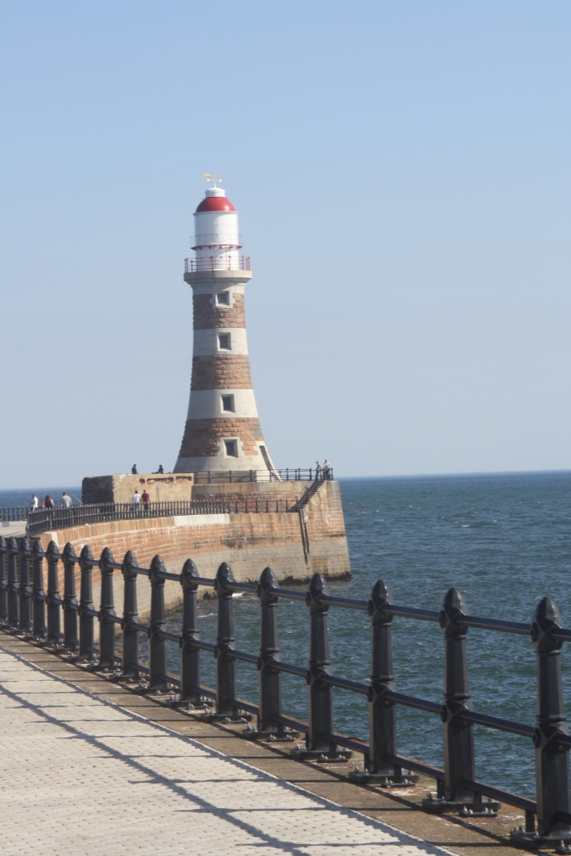
Roker Pier and Lighthouse with
railings, lamp standards and part of
promenade
GV II
Pier and lighthouse with lamp standards and railings; short
continuation of structure along promenade. 1885-1903. First
recommendations by Sir John Coode 1876, amended by River Wear
Commission engineer Henry Hay Wake in 1882. Rubble and cement
foundation with red and white granite pier and lighthouse;
cast-iron railings.
Curved plan pier approx 900 metres long, extending from
parapet approx 100 metres to N along promenade and from wall
in quadrant curve to S. Rock-faced battered red pier walls
with ashlar coping of large white granite blocks extend
northwards from pier to round-coped parapet on promenade, with
railings linking higher sections, and southwards to curved
wall with steps to beach. Steps up to round platform of
lighthouse with incurving walls of smooth white and rock-faced
red bands; iron gallery to high lantern with secondary gallery
and domed top. Plain stone surround to steps and metal door in
S and to 4 recessed fixed lights, one in each band of colour,
those set in red granite having alternate block white jambs,
the top 3 lights with glazing bars and the lowest blocked.
Railings along pier from Promenade to pier gate are tapered
and round, with lozenges at centre and top pierced to hold
renewed rails, and are bolted to the pier; some lamposts of
same design incorporated. Seaward half of railings renewed
except for those around lighthouse. Foundation stone 14
September 1885 and completion recorded on stone dated 23
September 1903, Engineer Henry Hay Wake M Inst CE for River
Wear Commissioners, set in lightouse.
This was the only one of the two piers begun by Wake to be
completed, the new S Pier being abandoned shortly after. In
1903 this was the most powerful port light in the country.
(Milburn GE and Miller ST: Sunderland River, Town and People:
Sunderland: 1988-: 19).
Listing NGR: NZ4107458896
External links are from the relevant listing authority and, where applicable, Wikidata. Wikidata IDs may be related buildings as well as this specific building. If you want to add or update a link, you will need to do so by editing the Wikidata entry.


Other nearby listed buildings
