Latitude: 50.5471 / 50°32'49"N
Longitude: -2.4451 / 2°26'42"W
OS Eastings: 368558
OS Northings: 72016
OS Grid: SY685720
Mapcode National: GBR PY.JRS9
Mapcode Global: FRA 57RM.C6W
Plus Code: 9C2VGHW3+RX
Entry Name: Church of St George, Graveyard Wall
Listing Date: 21 September 1978
Grade: II
Source: Historic England
Source ID: 1280219
English Heritage Legacy ID: 382075
ID on this website: 101280219
Location: Easton, Dorset, DT5
County: Dorset
Civil Parish: Portland
Traditional County: Dorset
Lieutenancy Area (Ceremonial County): Dorset
Church of England Parish: Portland All Saints
Church of England Diocese: Salisbury
Tagged with: Architectural structure
PORTLAND
SY67SE WESTON ROAD, Easton
969-1/1/84 (West side)
21/09/78 Church of St George, graveyard wall
GV II
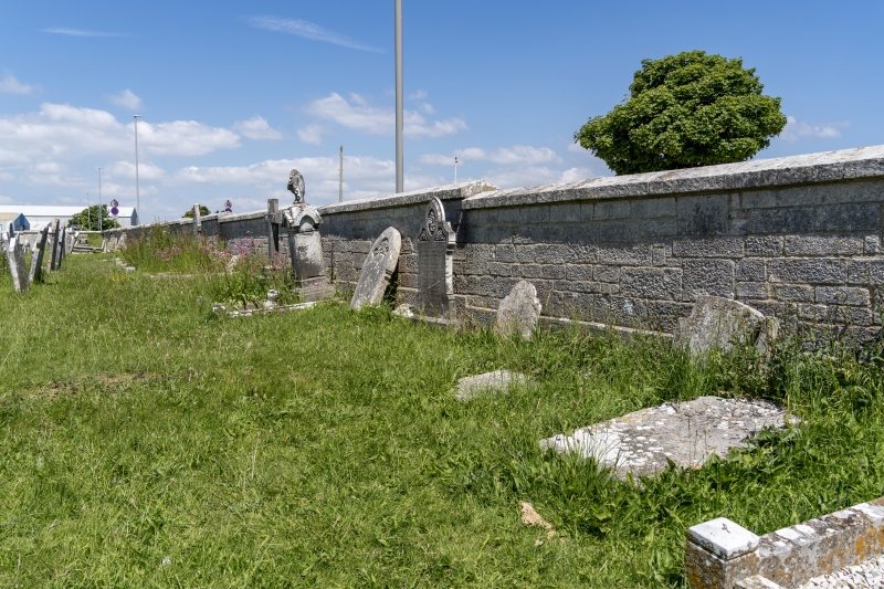
Wall enclosing graveyard, and as boundary to road to E.
Probably 1754, but return at S end said to be C20 replacement.
Portland ashlar. A long roughly rectangular enclosure with the
church (qv) set very close to the Lych Gate (qv) centred on
the E side. A series of long stepped panels, following changes
in ground line, on square plinth and with weathered
oversailing coping; centred to return walls at N and S ends an
opening, withour gates, with square piers to heavy pyramidal
cappings at c 1.75m. The wall, generally c 1.6m high,
completely encloses this large graveyard which contains large
numbers of monuments in Portland stone, from the mid-C18 to
the present day. This comprises an unusally complete
historical record of the Island families through that time.
Listing NGR: SY6855872016
External links are from the relevant listing authority and, where applicable, Wikidata. Wikidata IDs may be related buildings as well as this specific building. If you want to add or update a link, you will need to do so by editing the Wikidata entry.


Other nearby listed buildings