Latitude: 51.9907 / 51°59'26"N
Longitude: -2.1611 / 2°9'39"W
OS Eastings: 389035
OS Northings: 232479
OS Grid: SO890324
Mapcode National: GBR 1JR.0H5
Mapcode Global: VH93T.H7C9
Plus Code: 9C3VXRRQ+7H
Entry Name: Group of Three Monuments Approximately 20 Metres North of North Wall of Abbey Nave
Listing Date: 25 April 1994
Grade: II
Source: Historic England
Source ID: 1281116
English Heritage Legacy ID: 376584
ID on this website: 101281116
Location: St Mary's Abbey Church, Tewkesbury, Gloucestershire, GL20
County: Gloucestershire
District: Tewkesbury
Civil Parish: Tewkesbury
Built-Up Area: Tewkesbury
Traditional County: Gloucestershire
Lieutenancy Area (Ceremonial County): Gloucestershire
Church of England Parish: Tewkesbury St Mary the Virgin (Tewkesbury Abbey)
Church of England Diocese: Gloucester
Tagged with: Monument
TEWKESBURY
SO8932 ABBEY CHURCHYARD, Abbey Precincts 859-1/6/373 Group of three monuments approx. 20 metres north of north wall of Abbey nave
GV II
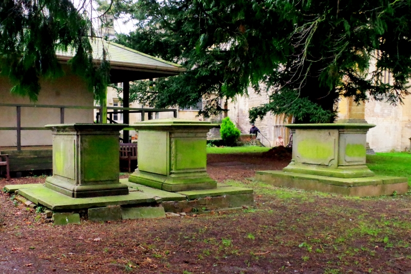
Group of 3 monuments in N/S line. C18 and C19. (i) Chest tomb. 1788. Sandstone. To George VERNON, d.1788 aged 17. Flat ledger slab to moulded edges, raised panels, flared cavetto base on platform. Further inscriptions on the ledger, including Thomas, 1805, in infancy, and Susannah, 1807, aged 2 weeks, and others up to 1973. The inscriptions to S and E appear to have been recut; (ii) Upright chest tomb. Mid C19. Sandstone. To William MOORE and others. Flat pyramidal ledger with leaf enrichment to arrises, moulded edges, raised panels, inset ends to moulded cornice and base, on cavetto base, and platform shared with Merrett monument; (iii) Chest tomb. 1833. Sandstone. To Thomas MERRETT, 1833, and others. Flat ledger slab to moulded edges, raised panels, inset ends, all to a common cornice mould, on a bulbous ovolo-mould base and platform shared with adjacent MOORE monument.
Listing NGR: SO8903532479
External links are from the relevant listing authority and, where applicable, Wikidata. Wikidata IDs may be related buildings as well as this specific building. If you want to add or update a link, you will need to do so by editing the Wikidata entry.


Other nearby listed buildings