Latitude: 52.5877 / 52°35'15"N
Longitude: -2.1192 / 2°7'8"W
OS Eastings: 392023
OS Northings: 298886
OS Grid: SO920988
Mapcode National: GBR 1GJ.8R
Mapcode Global: WHBFZ.F730
Plus Code: 9C4VHVQJ+38
Entry Name: Retaining Wall and Arcade to South West of Low Level Station Forecourt
Listing Date: 20 February 1987
Grade: II
Source: Historic England
Source ID: 1282465
English Heritage Legacy ID: 378635
ID on this website: 101282465
Location: Wolverhampton, West Midlands, WV10
County: City of Wolverhampton
Electoral Ward/Division: Heath Town
Parish: Non Civil Parish
Built-Up Area: Wolverhampton
Traditional County: Staffordshire
Lieutenancy Area (Ceremonial County): West Midlands
Church of England Parish: Wolverhampton St Stephen, Springfields
Church of England Diocese: Lichfield
Tagged with: Retaining wall
WOLVERHAMPTON
SO99NW WEDNESFIELD ROAD
895-1/5/354 (South side)
20/02/87 Retaining wall and arcade to south
west of Low Level Station forecourt
(Formerly Listed as:
Retaining wall and arcade on NW side
of BR High Level line)
GV II
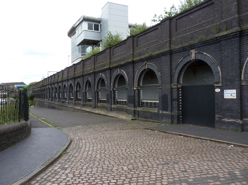
Retaining wall to high level railway line incorporating an
arcaded pedestrian gallery known as "The Colonnades" and
underpass. 1882-4. For the London and North Western Railway
(high level line). Brick with blue engineering brick, ashlar
and cast-iron details; white glazed bricks lining to gallery
and underpass. From the west abutment of the Corn Hill railway
bridge (not included), 2 and a half bays to north followed by
3 bays in quadrant curve to the west, thence continued by 27
bays facing the forecourt of the Low Level Station (q.v.), and
a further 25 bays are pierced to form an open arcade on the
north east side of the gallery. The 2 bays at either end of
the gallery have full-height openings, but the intermediate 21
arches have parapets capped by decorative cast-iron railings.
The gallery is entered in the centre of its length from a
tiled underpass approached by steps leading from the forecourt
of the High Level Station. A plain half bay links the arcaded
wall with the east abutment of the Wednesfield Road railway
bridge (q.v.). The bays of the retaining wall are defined by
full-height pilaster strips on continuous offset plinth with a
moulded stone capping, with cornice and high stone-coped brick
parapet; plinths and cornice break round pilaster strips. Each
bay has large square panel, and similar panel to parapet. Each
arcade bay has a round brick arch with stone hoodmould,
imposts and keystone; intermediate bays have stone-coped
parapet with decorative cast-iron railings with knopped
handrails. The gallery has shallow groin vaulting lined with
glazed bricks; the bay at the west end is partly infilled with
a later brick gas meter house. The pedestrian gallery and
underpass provide access to High Level and Low Level stations.
Included for group value with Low Level Station (q.v.).
Listing NGR: SO9202398886
External links are from the relevant listing authority and, where applicable, Wikidata. Wikidata IDs may be related buildings as well as this specific building. If you want to add or update a link, you will need to do so by editing the Wikidata entry.


Other nearby listed buildings