Approximate Location Map
Large Map »
Latitude: 54.1623 / 54°9'44"N
Longitude: -3.1881 / 3°11'17"W
OS Eastings: 322517
OS Northings: 474711
OS Grid: SD225747
Mapcode National: GBR 6N59.KP
Mapcode Global: WH72B.0M3Y
Plus Code: 9C6R5R66+WP
Entry Name: Garden Wall to South and West of Elliscale Farmhouse Including Farm Building Attached to South West
Listing Date: 6 May 1976
Last Amended: 20 December 1993
Grade: II
Source: Historic England
Source ID: 1283031
English Heritage Legacy ID: 388397
ID on this website: 101283031
Location: Dalton-in-Furness, Westmorland and Furness, Cumbria, LA15
County: Cumbria
District: Barrow-in-Furness
Civil Parish: Dalton Town with Newton
Traditional County: Lancashire
Lieutenancy Area (Ceremonial County): Cumbria
Church of England Parish: Dalton-in-Furness St Mary
Church of England Diocese: Carlisle
Tagged with: Wall
BARROW IN FURNESS
SD2274 ASKAM ROAD, Dalton In Furness
708-1/10/154 (East side)
06/05/76 Garden wall to S and W of Elliscale
Farmhouse inc farm building attached
at SW
(Formerly Listed as:
ASKAM ROAD, Dalton
Garden wall with bee-boles to W of
Elliscale Farmhouse)
GV II
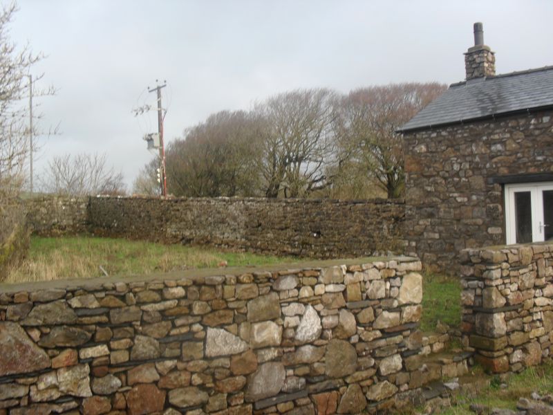
Wall with attached farm building. C18-early C19. Rubble
limestone; farmbuilding has slate roof. Wall encloses garden
to south of Elliscale Farmhouse (qv) then continues west to
join 2-storey, 3-bay farm building; from north-west corner of
this building the wall continues northwards as a high
retaining wall then returns eastwards to finish near rear-left
corner of house; this last section contains 6 bee-boles facing
south. Wall: gate piers opposite house door; short section to
west of house demolished; rough slab copings. Retaining wall
section is approx 4m in height and has slate throughs.
Bee-boles have 4 brick partitions and one of limestone; slate
projection over. Farm building: large quoins; loose box and
stable doorways to east. Hayloft entered from farm drive via
double doors in south gable formerly covered by slated canopy.
INTERIOR: 2 principal-rafter trusses. Included for group
value.
Listing NGR: SD2251774711
External links are from the relevant listing authority and, where applicable, Wikidata. Wikidata IDs may be related buildings as well as this specific building. If you want to add or update a link, you will need to do so by editing the Wikidata entry.


Other nearby listed buildings
