Approximate Location Map
Large Map »
Latitude: 51.6605 / 51°39'37"N
Longitude: -2.3763 / 2°22'34"W
OS Eastings: 374070
OS Northings: 195812
OS Grid: ST740958
Mapcode National: GBR 0M0.S2Z
Mapcode Global: VH957.RJMF
Plus Code: 9C3VMJ6F+5F
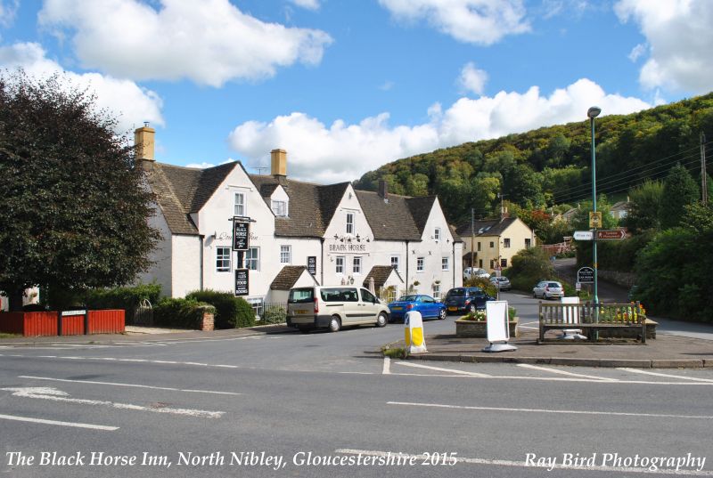
Entry Name: Black Horse Inn
Listing Date: 23 June 1952
Grade: II
Source: Historic England
Source ID: 1290709
English Heritage Legacy ID: 394679
Also known as: The Black Horse Inn, Dursley
ID on this website: 101290709
Location: North Nibley, Stroud, Gloucestershire, GL11
County: Gloucestershire
District: Stroud
Civil Parish: North Nibley
Built-Up Area: North Nibley
Traditional County: Gloucestershire
Lieutenancy Area (Ceremonial County): Gloucestershire
Church of England Parish: North Nibley St Martin
Church of England Diocese: Gloucester
NORTH NIBLEY BARR'S LANE
ST 7495
(west side)
10/97 Black Horse Inn
23.6.52
II
Coaching inn. Early C18; extensive early C19 additions; C20
alterations. Roughcast render to front and sides, coursed
limestone rubble to rear; ashlar limestone and brick chimneys;
stone slate roof. Long 2-storey range with attic; 2-storey block
at rear. Front: 3 gables with mixed fenestration, generally
single-window to attic in gables and 2-window below. Sashes are
mix of early Cl9 6-pane and later C19 4-pane; some C20 small-paned
casements. Central gable has long hoodmould to upper floor and
hoodmould to attic sash in gable. Single attic sash in left gable
also has hoodmould in imitation of the others. Two C20 gabled
porches toward centre of elevation. Single ridge-mounted brick
chimney between centre and right gables. Tall ridge-mounted ashlar
chimneys with left-hand gable between indicate extent of early C19
addition to this range. Rear: parallel-roofed early C19 addition
with segmental-arched casement fenstration. To right of this full
attic gable to rear of main range. Building stands at focal point
of central village cross-roads.
Listing NGR: ST7407095812
External links are from the relevant listing authority and, where applicable, Wikidata. Wikidata IDs may be related buildings as well as this specific building. If you want to add or update a link, you will need to do so by editing the Wikidata entry.


Other nearby listed buildings
