Latitude: 53.3708 / 53°22'15"N
Longitude: -2.9989 / 2°59'55"W
OS Eastings: 333636
OS Northings: 386462
OS Grid: SJ336864
Mapcode National: GBR 7YHG.KC
Mapcode Global: WH87D.XJ4P
Plus Code: 9C5V92C2+8C
Entry Name: Numbers 14 and 15 with Gatepiers to Front Garden
Listing Date: 13 March 1973
Grade: II
Source: Historic England
Source ID: 1291789
English Heritage Legacy ID: 389318
ID on this website: 101291789
Location: Rock Park, Wirral, Merseyside, CH42
County: Wirral
Electoral Ward/Division: Rock Ferry
Parish: Non Civil Parish
Built-Up Area: Birkenhead
Traditional County: Cheshire
Lieutenancy Area (Ceremonial County): Merseyside
Church of England Parish: Rock Ferry St Peter
Church of England Diocese: Chester
Tagged with: Building
BIRKENHEAD
SJ3386 ROCK PARK, Rock Ferry
789-1/12/258 (East side)
13/03/73 Nos.14 AND 15
with gatepiers to front garden
GV II
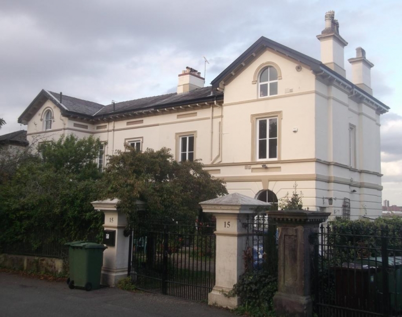
Pair of houses. c1836. Stucco, rusticated to ground floor with
Welsh slate roof. Italianate style, 2 storeys with attic and
basement, 2-unit double-pile plan. Symmetrically-designed with
central entrance to each house in porch to angle formed by the
outer advanced gabled wings. Round-arched in single-storey
porches flanked by 4-pane round-arched sash windows. Cast-iron
balustrade to basement area. Upper windows are also 4-pane
sashes in shouldered architraves. All windows renewed in
original openings to No.14. Round arched attic window in apex
of gabled outer wing. Eaves overhang on brackets, and
bargeboards return to pediment the gable. End wall and axial
stacks. No.14 has further advanced hipped gable to left with
tripartite sash window to ground floor and 4-pane sash window
above. Elevation to Esplanade has 2-storeyed canted bay window
in outer gable with parapet, and balcony to first floor in
central range. Cast-iron balustrade and canopy carried on cast
iron columns survives to No.14 only. Dormer window recessed in
segmental pediment which cuts the eaves cornice in central
range. End wall and axial stacks. Paired square gate piers to
street with shallow pyramidal caps. The houses form part of
the original development of Rock Park, laid out in 1836 by
J.Bennison.
(The Buildings of England: Pevsner N and Hubbard E: Cheshire:
Harmondsworth: 1971-).
Listing NGR: SJ3363686462
External links are from the relevant listing authority and, where applicable, Wikidata. Wikidata IDs may be related buildings as well as this specific building. If you want to add or update a link, you will need to do so by editing the Wikidata entry.


Other nearby listed buildings