Latitude: 53.3716 / 53°22'17"N
Longitude: -2.9998 / 2°59'59"W
OS Eastings: 333578
OS Northings: 386549
OS Grid: SJ335865
Mapcode National: GBR 7YHG.C2
Mapcode Global: WH87D.WJQ3
Plus Code: 9C5V92C2+J3
Entry Name: Numbers 10 and 11 with Area Ironwork and Gatepiers to Front Garden
Listing Date: 13 March 1973
Grade: II
Source: Historic England
Source ID: 1218794
English Heritage Legacy ID: 389316
ID on this website: 101218794
Location: Rock Park, Wirral, Merseyside, CH42
County: Wirral
Electoral Ward/Division: Rock Ferry
Parish: Non Civil Parish
Built-Up Area: Birkenhead
Traditional County: Cheshire
Lieutenancy Area (Ceremonial County): Merseyside
Church of England Parish: Rock Ferry St Peter
Church of England Diocese: Chester
Tagged with: Building
BIRKENHEAD
SJ3386 ROCK PARK, Rock Ferry 789-1/12/256 (East side) 13/03/73 Nos.10 AND 11 with area ironwork and gatepiers to front garden
GV II
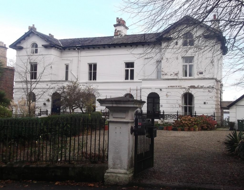
Pair of houses. c1836. Stucco, rusticated to ground floor, with Welsh slate roof. Italianate style. 2 storeys with attic and basement, symmetrically-designed with central porch occupying angle between main range and advanced outer gables and 3-window range to each house, the outer bays forming advanced gables. Each has central door with fanlight up steps in projecting porch. Gothick panelled door in No.11, renewed door to No.10. Flanking windows are round-arched 4-pane sashes. Four-pane sash windows to first floor in shouldered architraves and narrow window over the door. Round arched attic window in gable apex. Barge-boards return to pediment the gable. Overhanging eaves carried on brackets. Cast-iron balustrade to steps and basement each side with balusters at angles and scroll decoration. Square gate piers with shallow pyramidal caps, heavily overhanging to No.11. Elevation to Esplanade has canted bay window divided by pilasters to ground floor in gabled outer bays with balcony with cast iron balustrade above (to 1st-floor windows). There is another balustrade between the canted bays. Attic windows in this range are recessed in segmentally arched dormers which break the eaves line. The houses form part of the original Rock Park development which was laid out in 1836 by J.Bennison. (The Buildings of England: Pevsner N and Hubbard E: Cheshire: Harmondsworth: 1971-).
Listing NGR: SJ3357886549
External links are from the relevant listing authority and, where applicable, Wikidata. Wikidata IDs may be related buildings as well as this specific building. If you want to add or update a link, you will need to do so by editing the Wikidata entry.


Other nearby listed buildings