Latitude: 54.9139 / 54°54'50"N
Longitude: -1.3958 / 1°23'44"W
OS Eastings: 438833
OS Northings: 557857
OS Grid: NZ388578
Mapcode National: GBR V9M.88
Mapcode Global: WHD55.JRK9
Plus Code: 9C6WWJ73+HM
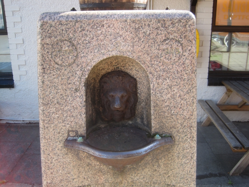
Entry Name: Drinking Fountain to West of Saltgrass Public House
Listing Date: 17 October 1994
Grade: II
Source: Historic England
Source ID: 1292011
English Heritage Legacy ID: 391642
ID on this website: 101292011
Location: Deptford, Sunderland, Tyne and Wear, SR4
County: Sunderland
Electoral Ward/Division: Millfield
Parish: Non Civil Parish
Built-Up Area: Sunderland
Traditional County: Durham
Lieutenancy Area (Ceremonial County): Tyne and Wear
Church of England Parish: Millfield St Mark
Church of England Diocese: Durham
Tagged with: Drinking fountain
SUNDERLAND
NZ3857 WELLINGTON LANE 920-1/10/233 (East side) Drinking fountain to west of Saltgrass Public House
II
Drinking fountain. 1893. A gift from John Laing to the people of Deptford to commemorate his father Philip Laing and the founding in 1793 of Laing's shipbuilding yard. Granite column with cast-iron basin and tap surround. Tapered square column, on stepped square base containing semicircular niches for dog drinking basins, has round-headed niche on W face containing lion mask tap surround over projecting fluted basin; dates 1793 and 1893 inscribed in circles at top corners above. E face has inscription recording gift. This fountain was originally surmounted by a female figure, since removed. Moved to this site from the centre of the road.
Listing NGR: NZ3883357857
External links are from the relevant listing authority and, where applicable, Wikidata. Wikidata IDs may be related buildings as well as this specific building. If you want to add or update a link, you will need to do so by editing the Wikidata entry.


Other nearby listed buildings