Latitude: 54.9172 / 54°55'1"N
Longitude: -1.3928 / 1°23'34"W
OS Eastings: 439020
OS Northings: 558222
OS Grid: NZ390582
Mapcode National: GBR VB1.W0
Mapcode Global: WHD55.KNZS
Plus Code: 9C6WWJ84+VV
Entry Name: Lime Kilns on North Bank of River Wear at NZ 3895 5826
Listing Date: 17 October 1994
Grade: II
Source: Historic England
Source ID: 1292063
English Heritage Legacy ID: 391619
ID on this website: 101292063
Location: Deptford, Sunderland, Tyne and Wear, SR5
County: Sunderland
Electoral Ward/Division: Southwick
Parish: Non Civil Parish
Built-Up Area: Sunderland
Traditional County: Durham
Lieutenancy Area (Ceremonial County): Tyne and Wear
Church of England Parish: North Wearside
Church of England Diocese: Durham
Tagged with: Lime kiln
SUNDERLAND
NZ3858 THIRLWELL ROAD, Southwick 920-1/8/294 (South side (off)) Lime kilns on north bank of River Wear at NZ 3895 5826
GV II
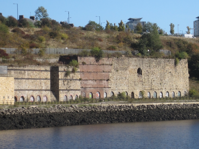
Lime kilns. Late C18, early C19 and mid C19. Sandstone and limestone rubble; coursed stone; and brick with iron ties. A long series of kilns set against the river bank between a mineral railway and the river, mostly in the grounds of Wearmouth Colliery, with access to the tops from the railway and access from the bottom to river transport. Maximum height perhaps 12 metres. Round-plan C18 kilns at left with some C20 patching at base have lost part of front walls; central stone kilns of squared plan have row of small arches at foot of tall wall; second similar set to right, and a third row of stone kilns at extreme right has a row of blocked arches in a projection at base of wall; between these last two stone groups is the last brick structure with iron bands and 4 arches, most blocked with stone and one blocked with brick. A significant survivor of the once flourishing lime-exporting business on the Wear, the major exporter of lime from the NE because of the unique conjunction of lime quarries and river transport. These kilns were supplied by waggonway with stone from Carley Hill quarry, and an etching by E Swinburne published in 1839 shows them in use (Sinclair 1986). (Sinclair NT: Railways of Sunderland: Newcastle upon Tyne: 1986-: 6 AND 7).
Listing NGR: NZ3902058221
External links are from the relevant listing authority and, where applicable, Wikidata. Wikidata IDs may be related buildings as well as this specific building. If you want to add or update a link, you will need to do so by editing the Wikidata entry.


Other nearby listed buildings