Approximate Location Map
Large Map »
Latitude: 54.8657 / 54°51'56"N
Longitude: -1.3724 / 1°22'20"W
OS Eastings: 440376
OS Northings: 552504
OS Grid: NZ403525
Mapcode National: GBR LDV5.NK
Mapcode Global: WHD5C.WYMR
Plus Code: 9C6WVJ8H+72
Entry Name: Cooling Ponds to North and South and Reservoir to East of Ryhope Pumping Station
Listing Date: 19 June 1974
Last Amended: 17 October 1994
Grade: II
Source: Historic England
Source ID: 1292116
English Heritage Legacy ID: 391600
ID on this website: 101292116
Location: Ryhope, Sunderland, Tyne and Wear, SR2
County: Sunderland
Electoral Ward/Division: Ryhope
Parish: Non Civil Parish
Built-Up Area: Sunderland
Traditional County: Durham
Lieutenancy Area (Ceremonial County): Tyne and Wear
Church of England Parish: Ryhope
Church of England Diocese: Durham
Tagged with: Pond
SUNDERLAND
NZ45SW STOCKTON ROAD, Ryhope
920-1/7/262 (West side (off))
19/06/74 Cooling ponds to north & south and
reservoir to east of Ryhope Pumping
Station
(Formerly Listed as:
RYHOPE
3 cooling ponds to N, S and E of
main building at Ryhope Pumping
Station)
GV II
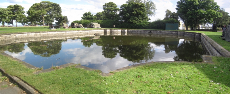
2 cooling ponds and one reservoir for water pumping station.
1866-70. By T Hawksley. For the Sunderland and South Shields
Water Co. Rock-faced snecked stone walls with ashlar coping. 2
small cooling ponds with shaped corners are N and S of the
engine house. The walls slope back towards the coping. The
large reservoir lies across the width of the site to E of the
engine house but is covered and grassed over at time of survey
with gauges set into a concrete platform in the turf.
Listing NGR: NZ4037652504
External links are from the relevant listing authority and, where applicable, Wikidata. Wikidata IDs may be related buildings as well as this specific building. If you want to add or update a link, you will need to do so by editing the Wikidata entry.


Other nearby listed buildings
