Approximate Location Map
Large Map »
Latitude: 52.4549 / 52°27'17"N
Longitude: -1.2016 / 1°12'5"W
OS Eastings: 454349
OS Northings: 284405
OS Grid: SP543844
Mapcode National: GBR 8PP.30D
Mapcode Global: VHCTD.4K3F
Plus Code: 9C4WFQ3X+X9
Entry Name: 14, Bank Street
Listing Date: 16 January 1989
Grade: II
Source: Historic England
Source ID: 1292200
English Heritage Legacy ID: 392547
ID on this website: 101292200
Location: Lutterworth, Harborough, Leicestershire, LE17
County: Leicestershire
District: Harborough
Civil Parish: Lutterworth
Built-Up Area: Lutterworth
Traditional County: Leicestershire
Lieutenancy Area (Ceremonial County): Leicestershire
Church of England Parish: Lutterworth St Mary
Church of England Diocese: Leicester
Tagged with: Building
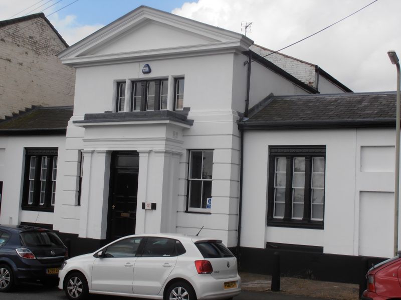
LUTTERWORTH
BANK STREET
SP5484
1323-0/9/56 (West side)
16/01/89 No.14
II
Former bank, now offices. Circa 1835, possibly by J Hansom .
Greek Revival. Stuccoed brick, rusticated on ground floor of
central section only. Welsh slate roofs. Symmetrical, 3 units,
the centre of 2 storeys, the side bays of one. Heavily moulded
gable-pediment over central section with band over ground.
Recessed and moulded tripartite window on first floor of
centre; to ground, narrow glazing bar sash to each side
flanking projecting flat-headed porch with paired pilasters to
sides and front supporting full entablature. Half-glazed door
with transom-light over. Recessed single-storey wings with
single recessed tripartite sashes, each part divided by antae,
with modillion frieze over. Doorway to side entry to left,
blank panels to corresponding position right. Rear with tall
round-headed hall window with margin panes. Interior: central
hall with lozenge stone floor; stairway with cast-iron
fretwork tread and stick balusters, mahogany rail; internal
window to rear with cast-iron glazing bars having circles at
intersections.
Listing NGR: SP5434984405
External links are from the relevant listing authority and, where applicable, Wikidata. Wikidata IDs may be related buildings as well as this specific building. If you want to add or update a link, you will need to do so by editing the Wikidata entry.


Other nearby listed buildings
