Latitude: 53.3893 / 53°23'21"N
Longitude: -3.0308 / 3°1'50"W
OS Eastings: 331541
OS Northings: 388546
OS Grid: SJ315885
Mapcode National: GBR 7Y87.MR
Mapcode Global: WH87D.D2ZJ
Plus Code: 9C5R9XQ9+PM
Entry Name: 1-7, Charing Cross
Listing Date: 28 March 1974
Grade: II
Source: Historic England
Source ID: 1292250
English Heritage Legacy ID: 389144
Also known as: Bank Buildings, Birkenhead
ID on this website: 101292250
Location: Wirral, Merseyside, CH41
County: Wirral
Electoral Ward/Division: Birkenhead and Tranmere
Parish: Non Civil Parish
Built-Up Area: Birkenhead
Traditional County: Cheshire
Lieutenancy Area (Ceremonial County): Merseyside
Church of England Parish: Birkenhead Christ the King
Church of England Diocese: Chester
Tagged with: Building Shop Gothic Revival Commercial building
BIRKENHEAD
SJ3188 CHARING CROSS 789-1/11/40 (North side) 28/03/74 Nos.1-7 (Consecutive)
GV II
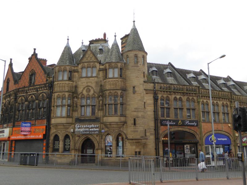
Range of 7 shops and offices, originally including bank. 1901. By Douglas and Minshull. Brick ground floor with ashlar above, and Westmorland slate roof. 2 storeys, 4-bay elevation to Charing Cross, corner block, and return elevation to Grange Road West of 2 bays. Elevation to Charing Cross has wide segmental arch to each shop front, now filled in with C20 fronts, and above each bay three paired trefoiled windows with transoms and leaded lights forming a continuous range. Balustraded parapet carried on corbels, and steeply pitched roof with 2 small gabled dormers with leaded lights. Cast-iron rainwater goods and gargoyle between each unit. Asymmetrical corner block with canted tower at each side corbelled out over ground floor with conical roofs. Each has bands of lancet windows to first floor, then plain panelled band above. They flank central gable with paired arched windows each side of central Decorated style door with shafts and deep moulding. Triple lancets in stepped arched hoodmould to first floor, ogee lancets also grouped in threes above. Blind interlace tracery panelling below eaves. Stair tower projects to right, with small windows to stair, and band of lancet lights below eaves. Elevation to Grange Road West has inserted shop fronts to ground floor, and 3 paired lancet windows with transoms and moulded over-arches. Stone coping to brick gable over each, with leaded lancet lights to attic. Statues in crocketted niches each side of first floor windows. End wall stacks. A varied and lively treatment of an important corner site. (The Buildings of England: Nikolaus Pevsner and Edward Hubbard: Cheshire: Harmondsworth: 1971-).
Listing NGR: SJ3154188546
External links are from the relevant listing authority and, where applicable, Wikidata. Wikidata IDs may be related buildings as well as this specific building. If you want to add or update a link, you will need to do so by editing the Wikidata entry.


Other nearby listed buildings