Latitude: 51.5229 / 51°31'22"N
Longitude: -0.1067 / 0°6'24"W
OS Eastings: 531448
OS Northings: 182145
OS Grid: TQ314821
Mapcode National: GBR N8.67
Mapcode Global: VHGQT.3ZGD
Plus Code: 9C3XGVFV+58
Entry Name: 18 and 20, Farringdon Lane
Listing Date: 30 September 1994
Grade: II
Source: Historic England
Source ID: 1292621
English Heritage Legacy ID: 368889
ID on this website: 101292621
Location: Clerkenwell, Islington, London, EC1R
County: London
District: Islington
Electoral Ward/Division: Clerkenwell
Parish: Non Civil Parish
Built-Up Area: Islington
Traditional County: Middlesex
Lieutenancy Area (Ceremonial County): Greater London
Church of England Parish: St James Clerkenwell
Church of England Diocese: London
Tagged with: Building
ISLINGTON
TQ3182SW FARRINGDON LANE 635-1/73/389 (East side) Nos.18 AND 20
GV II
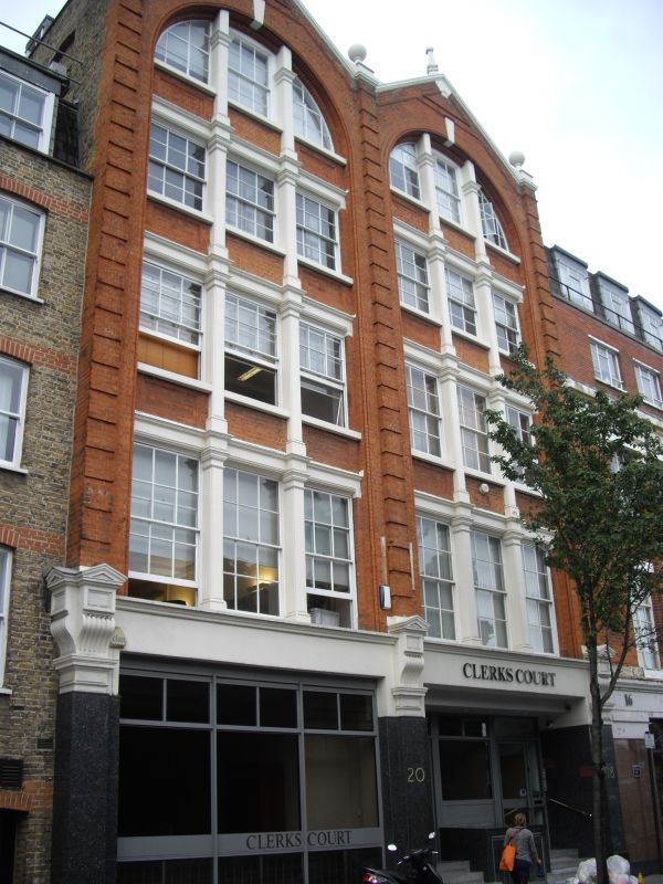
Commercial/light industrial building. Probably 1870s-1880s; C20 ground-floor. Rubbed red brick to upper floors, polished granite to ground-floor, stucco dressings; artificial slate mansard roof with dormers. Altered ground-floor plan. Five storeys with attic, 2-bays wide 3:3. Windows diminish in height as they go up: upper floors with 6/6 tripartite sashes set within recessed brick bays articulated by full height gauged-brick round-headed arches set beneath gables. Square-columns flanking centre sashes, banded brick giant pilasters extending to parapet level with stucco ball finials, and gable finials creating vertical emphasis; moulded stucco coping to gables. Altered ground-floor: original bracketed terracotta corbels supported by obliterated piers.
Listing NGR: TQ3144882145
External links are from the relevant listing authority and, where applicable, Wikidata. Wikidata IDs may be related buildings as well as this specific building. If you want to add or update a link, you will need to do so by editing the Wikidata entry.


Other nearby listed buildings