Approximate Location Map
Large Map »
Latitude: 51.6708 / 51°40'14"N
Longitude: 0.3854 / 0°23'7"E
OS Eastings: 565045
OS Northings: 199589
OS Grid: TQ650995
Mapcode National: GBR NJW.87Q
Mapcode Global: VHJKD.M8LH
Plus Code: 9F32M9CP+84
Entry Name: The Star Inn
Listing Date: 20 February 1976
Last Amended: 9 December 1994
Grade: II
Source: Historic England
Source ID: 1297197
English Heritage Legacy ID: 373684
Also known as: Star Inn
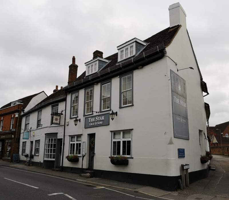
The Star Inn, Ingatestone
ID on this website: 101297197
Location: Ingatestone, Brentwood, Essex, CM4
County: Essex
District: Brentwood
Civil Parish: Ingatestone and Fryerning
Built-Up Area: Ingatestone
Traditional County: Essex
Lieutenancy Area (Ceremonial County): Essex
Church of England Parish: Ingatestone St Edmund and St Mary
Church of England Diocese: Chelmsford
This list entry was subject to a Minor Amendment on 16/04/2020
TQ 6599
723-1/14/402
INGATESTONE AND FRYERNING
Ingatestone
HIGH STREET (south east side)
The Star Inn
(Formerly listed as: BRENTWOOD, HIGH STREET The Star Inn)
20/02/76
GV
II
House, now public house. C18, extended in C19 and C20. Plastered brick and timber framing, roofed with handmade red clay tiles. Main range of rectangular plan facing north west with an internal axial stach in each side. Original window to rear right, of one bay, angled to follow the line of Star Lane, and two-bay extension beyond, the roof slightly lower with internal axial stack at end. C20 single storey extension beyond. C19/20 single storey lean-to extension with slate roof to rear left, and C20 single storey extension with slate roof beyond.
Main range of two storeys with attics, rear wing extension of two storeys. Ground floor two casements. First floor, four sashes of four+four lights with horns, regularly spaced, with a blank are to the right suggests that originally there was a fifth similar window. Two C20 dormers with casements and flat roofs, asymmetrically arranged. Off-centre C19 four-panels glazed with two stone steps. The shape of the right stack is cement-rendered and painted. In the right return of the main range, on the ground floor, is a sash of six+six lights with horns, and near the end of the two storey extension is a similar sash of eight+eight lights.
The roof of the original wing is half-hipped at the end. The stack in the extension had C19 twin diagonal shafts.
Known as 'The Hole in the Wall' c1900.
Listing NGR: TQ6504599589
External links are from the relevant listing authority and, where applicable, Wikidata. Wikidata IDs may be related buildings as well as this specific building. If you want to add or update a link, you will need to do so by editing the Wikidata entry.


Other nearby listed buildings
