Approximate Location Map
Large Map »
Latitude: 51.671 / 51°40'15"N
Longitude: 0.3852 / 0°23'6"E
OS Eastings: 565034
OS Northings: 199609
OS Grid: TQ650996
Mapcode National: GBR NJW.27N
Mapcode Global: VHJKD.M8HB
Plus Code: 9F32M9CP+C3
Entry Name: 82 and 84, High Street
Listing Date: 9 December 1994
Grade: II
Source: Historic England
Source ID: 1197299
English Heritage Legacy ID: 373671
ID on this website: 101197299
Location: Ingatestone, Brentwood, Essex, CM4
County: Essex
District: Brentwood
Civil Parish: Ingatestone and Fryerning
Built-Up Area: Ingatestone
Traditional County: Essex
Lieutenancy Area (Ceremonial County): Essex
Church of England Parish: Ingatestone St Edmund and St Mary
Church of England Diocese: Chelmsford
Tagged with: Building
INGATESTONE AND FRYERNING
TQ6599 HIGH STREET, Ingatestone
723-1/14/386 (North West side)
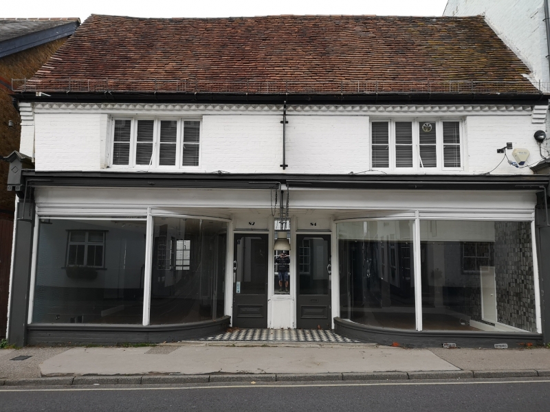
Nos.82 AND 84
GV II
House, now a shop. C17 or earlier, altered in late C19. Timber-framed, facade ofpaiiited brick in English bond, weatherboarded and rendered, roofed with handmade red clay tiles. Main range facing SE; wing to rear right, and single- storey lean-to beyond; shorter wing to rear centre, and larger extension beyond roofed with red clay pantiles; 2 single-storey lean-to extensions to rear left; the whole forming an almost rectangular plan.
One storey with attics. The ground floor has a continuous early C20 shopfront of 2 large windows and 2 recessed glazed doors; above, two C19 casements of 8 lights in brick facade with dogtooth course below eaves. The left elevation is partly of C19 red brick, partly cement rendered. The rear elevation, above the Ie-it rear extensions, is weatherboarded. One disused stack to rear of pantiled extension.
INTERIOR: the ground floor has been much altered for use as a shop, all internal studding removed, nearly all beams boxed, joists ceiled. The first floor of the left part has been raised and the soffit boarded, c1900, leaving less than a storey height between it and the ceiling above, which has a boxed axial beam. The right part has one exposed axial beam, chamfered, stops concealed, and another in the ceiling above, with runout stops. The rear right wing is ceiled to the rafters and collars of the roof. No access to roof structure. Included for group value.
Listing NGR: TQ6503499609
External links are from the relevant listing authority and, where applicable, Wikidata. Wikidata IDs may be related buildings as well as this specific building. If you want to add or update a link, you will need to do so by editing the Wikidata entry.


Other nearby listed buildings
