Approximate Location Map
Large Map »
Latitude: 51.4142 / 51°24'51"N
Longitude: -1.1427 / 1°8'33"W
OS Eastings: 459718
OS Northings: 168705
OS Grid: SU597687
Mapcode National: GBR 93B.CWW
Mapcode Global: VHCZG.4QS6
Plus Code: 9C3WCV74+MW
Entry Name: The Malthouse
Listing Date: 10 November 1983
Grade: II
Source: Historic England
Source ID: 1303485
English Heritage Legacy ID: 39546
ID on this website: 101303485
Location: Beenham Stocks, West Berkshire, RG7
County: West Berkshire
Civil Parish: Beenham
Built-Up Area: Beenham
Traditional County: Berkshire
Lieutenancy Area (Ceremonial County): Berkshire
Church of England Parish: Beenham Valence
Church of England Diocese: Oxford
Tagged with: Architectural structure
BEENHAM BEENHAM HILL
SU 56NE
3/36 The Malthouse
GV II
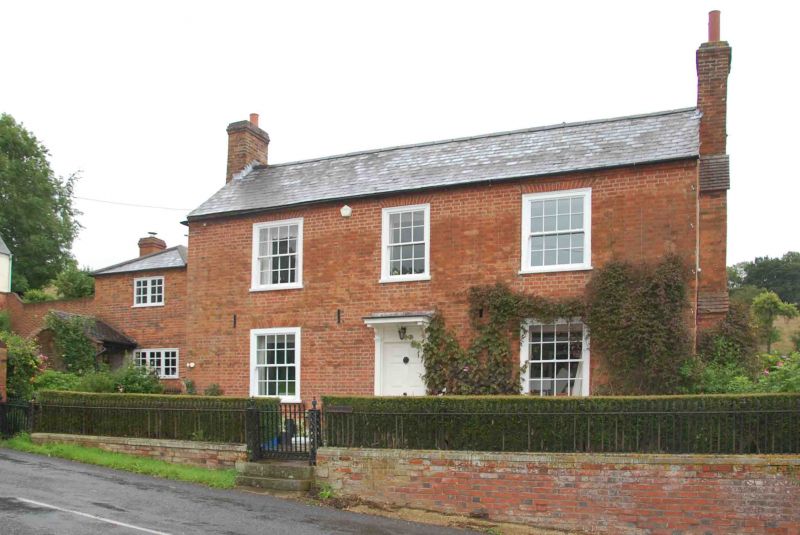
House. Early C19. Red brick with slate roof and end stacks to right and left.
2 storeys; 3 bays, glazing bar sashes with exposed wooden boxes and jalousies.
Central 6-panelled door with panelled pilasters and flat bracketted hoods.
Listing NGR: SU5971868705
External links are from the relevant listing authority and, where applicable, Wikidata. Wikidata IDs may be related buildings as well as this specific building. If you want to add or update a link, you will need to do so by editing the Wikidata entry.


Other nearby listed buildings
