Latitude: 53.7098 / 53°42'35"N
Longitude: -1.9025 / 1°54'9"W
OS Eastings: 406532
OS Northings: 423713
OS Grid: SE065237
Mapcode National: GBR HT4J.XW
Mapcode Global: WHB8N.R07T
Plus Code: 9C5WP35W+WX
Entry Name: The Wet Dock
Listing Date: 17 October 1975
Last Amended: 19 July 1988
Grade: II*
Source: Historic England
Source ID: 1313744
English Heritage Legacy ID: 339344
ID on this website: 101313744
Location: Calderdale, West Yorkshire, HX6
County: Calderdale
Electoral Ward/Division: Sowerby Bridge
Parish: Non Civil Parish
Built-Up Area: Halifax
Traditional County: Yorkshire
Lieutenancy Area (Ceremonial County): West Yorkshire
Church of England Parish: Sowerby Bridge Christ Church
Church of England Diocese: Leeds
Tagged with: Architectural structure
SOWERBY BRIDGE
1330/13/216 SOWERBY BRIDGE CANAL BASIN
17-OCT-75 THE WET DOCK
(Formerly listed as:
BOLTON BROW
SOWERBY BRIDGE CANAL BASIN
4
EAST WAREHOUSE)
GV II*
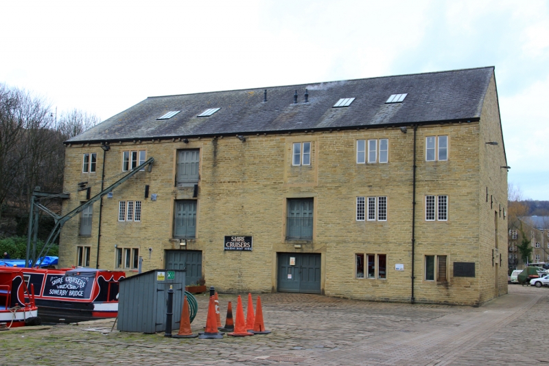
Canal wet dock and warehouse. Probably c.1775, for the Calder and Hebble Navigation Company. Coursed stone, corrugated asbestos roof. 3 storeys, 7 x 3 bays. West front: symmetrical facade, the central bay blind. Openings have plain stone surrounds, the windows with flat-faced mullions (some mullions removed). Bays 3 and 5 have a loading door on each floor, those on ground and 2nd floors of bay 5 now blocked and with 2-light windows. 3-light windows to bays 2 and 6. 2-light windows to bays 1 and 7, that to first floor of bay 1 made into door to give access to iron crane attached to left corner. Paired gutter brackets on table. Rear: as front. Right return: central loading door to ground and first floors. Left return, fronting basin: tall central archway giving access to wet dock flanked on ground and first floors by 3-light windows with small pane glazing (mullions of ground-floor left window removed). Interior: central longitudinal bay forms wet dock. Chamfered timber posts support large scantling beams. First floor: remains of machinery suspended from ceiling. Trap doors here and on second floor. Elaborate roof trusses with vertical and diagonal members.
History. Tenders were invited for the building of a first warehouse on the basin in 1770, this presumably being The Moorings (No 1) (qv); another warehouse had been built by 1778 and others decided upon in 1788 and 1792. Included at grade II* as an exceptionally fine and well-preserved warehouse.
Sources: (Hadfield, p58, Sowerby Bridge p 23). C Hadfield, Canals of Yorkshire and North-East England (1972).
Sowerby Bridge, Chamber of Trade and Commerce Official Guide.
Listing NGR: SE0653223713
External links are from the relevant listing authority and, where applicable, Wikidata. Wikidata IDs may be related buildings as well as this specific building. If you want to add or update a link, you will need to do so by editing the Wikidata entry.


Other nearby listed buildings