Approximate Location Map
Large Map »
Latitude: 54.2652 / 54°15'54"N
Longitude: -0.856 / 0°51'21"W
OS Eastings: 474607
OS Northings: 486104
OS Grid: SE746861
Mapcode National: GBR QMG3.GT
Mapcode Global: WHF9V.T2K2
Plus Code: 9C6X748V+3H
Entry Name: Barn Approximately 10 Metres North East of the Hall
Listing Date: 10 November 1953
Last Amended: 27 August 1987
Grade: I
Source: Historic England
Source ID: 1315676
English Heritage Legacy ID: 382504
Also known as: The Old Hall
The Old Hall, 50m north west of All Saints Church
ID on this website: 101315676
SINNINGTON NUNS WALK
SE 78 NW
(north side)
8/86 Barn approximately
10 metres north-east of
The Hall
10.11.53
(formerly listed as Chapel
or Hall 60 yards north of
All Saints Church)
GV I
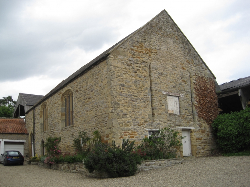
Grange hall, later used as a Chapel; now barn. Late C12, converted to
chapel before 1430; refenestrated before 1430; floor inserted c1430;
reroofed probably in C17 or later; further later alterations. Grange hall
probably built for Guisborough Priory. Corallian limestone with slate roof.
West front: 2 storeys, 2 windows. 2 doorways to left. End opening double
chamfered with 2-centred, roll-moulded arch over a board door and screen
with a square-paned pointed overlight. To right of this a lower plank door
in a chamfered opening with rough quoins and 2-centred arch. Over this door
and to right are 2 blocked 3-light windows with cusped pointed heads in
elliptical-arched, double-chamfered openings. East front: 2 storeys with
irregular openings. Inserted doorway with timber lintel to right of centre.
At centre left an earlier blocked doorway with 2-centred head. Further
left, a deeply-splayed chamfered opening with a segmental head containing a
recessed trefoil-headed light. To right of blocked doorway at first-floor
level an original window, partly decayed, of 2 pointed lights with
colonnettes beneath a shallow pointed outer arch on colonnettes which show
traces of waterleaf capitals. Further to right another, partly blocked,
elliptical-arched, 3-light window similar to those on west front. Gable
wall to south: later openings on ground floor. Above, 5-light window in
double-chamfered opening, almost completely blocked. Interior is divided
into 3 unequal parts by 2 massive beams, one chamfered, the other finely-
moulded: both have mortices on their lower side for partitions which were in
place in the early C20. 4-centred arch to south window over a moulded beam
carved with floral motifs. Roof consists of 6 trusses with chamfered tie
beams; wind-braced purlins and sprocketed rafters. History. After 1168
Ralphe de Clere gave to the Benedictine nuns at Yedingham the Church (qv) at
Sinnington, together with lands; and a grange site to Guisborough Priory.
In 1239 the Yedingham nuns agreed to support the Chapel and buildings owned
by the Guisborough Priory for the purpose of entertaining the Canons. The
Grange was let back to Simon of Guisborough in 1368. In 1431-32, Matilda of
York, whose second husband was John, Lord Latimer, paid for the installation
of partitions and flooring in the "Chapel at Sinnington" and for other works
including the filling of holes and "old windows under the space of the said
room". After the dissolution the grange probably passed to William
Thwaytes, as the Rectory. Building in dilapidated condition at time of
resurvey. Scheduled Ancient Monument No 146. Sources: J McConnel "The
Bridge on Sinnington Green", The Ryedale Historian, No 2, April 1966, pp 50-
53. North Yorkshire and Cleveland Vernacular Building Study Group report
no 611, Sinnington, former Hall. Colin Platt, The Monastic Grange in
Medieval England, 1969, p 233. J Rushton, The Ryedale Story, second edition
1986, p 129. Victoria County History of the Counties of England: York,
North Riding, Vol II, p 492.
Listing NGR: SE7460786104
External links are from the relevant listing authority and, where applicable, Wikidata. Wikidata IDs may be related buildings as well as this specific building. If you want to add or update a link, you will need to do so by editing the Wikidata entry.


Other nearby listed buildings
