Approximate Location Map
Large Map »
Latitude: 50.3313 / 50°19'52"N
Longitude: -4.7565 / 4°45'23"W
OS Eastings: 203913
OS Northings: 51563
OS Grid: SX039515
Mapcode National: GBR N1.XG1S
Mapcode Global: FRA 08X5.4S1
Plus Code: 9C2Q86JV+G9
Entry Name: Charlestown Harbour, comprising the inner dock and quays; outer basin and piers; eastern breakwater; and the eastern wall
Listing Date: 11 March 1974
Last Amended: 13 May 2022
Grade: II*
Source: Historic England
Source ID: 1327290
English Heritage Legacy ID: 70674
ID on this website: 101327290
Location: Charlestown, Cornwall, PL25
County: Cornwall
Civil Parish: St Austell Bay
Built-Up Area: St Austell
Traditional County: Cornwall
Lieutenancy Area (Ceremonial County): Cornwall
Church of England Parish: Charlestown
Church of England Diocese: Truro
Tagged with: Wharf
Harbour, comprising an inner wet-dock and outer basin and associated infrastructure. Built from 1790 for Charles Rashleigh to the designs and advice of John Smeaton; inner dock extended around 1871; various later additions including a period of expansion of the china-clay infrastructure from 1906-09 by Lovering & Company.
Harbour, comprising an inner wet-dock and outer basin and associated infrastructure. Built from 1790 for Charles Rashleigh to the designs and advice of John Smeaton; inner dock extended around 1871; various later additions including a period of expansion of the china-clay infrastructure from 1906-09 by Lovering & Company.
MATERIALS: the principal construction material of the C18 harbour is granite moorstone, probably from the Carn Grey area. The eastern sea-wall of the outer basin is Devonian limestone. Some later structures are of shuttered concrete.
PLAN: the entrance to the outer basin faces east, enclosed by a banjo pier lying east-west and a pier north-south on the eastern side. Contained by a dock gate lies the inner wet-dock which is roughly rectangular, and sits within a larger area contained to the east by a high retaining-wall to Quay Road and a slope from Charlestown Road to the west, and to the north by the tall excavated face of the bedrock.
DETAILS
Whilst the form of the inner dock and its quays and the outer basin and its piers are clear, Charlestown Harbour is a complex and interlinked series of structures. For ease of understanding it is described here in three separate sections.
THE INNER DOCK: the inner dock is primarily accessed today via a slope running from and parallel-to Charlestown Road. The slope is bordered with railings (see Ancillary Features, below) and about halfway along its length is a flight of granite steps up to street-level. The inner dock was quarried at first back from the line of the beach in 1796 and then in around 1871 it was extended through the bedrock to the north. The line of the original extent of the inner dock is not clear although there are changes in alignment, particularly on the eastern side. The walls enclosing the dock area are mainly granite ashlar blocks, although the north wall is excavated rock; the dock itself is of the same material. At its inner (north) end the dock is divided into two bays separated by a central pier. The bays are finished with dressed-granite kerb stones along the tops of the quays, and there is a flight of granite steps down the end of the pier. At the inner ends of the bays the piers are decoratively curved around towards sluice points, which contain two water channels once fitted with wooden sluice gates. Paving on the quays is mainly squared granite blocks, and some have drill marks visible on them; the southern end of the western quay has been rebuilt or resurfaced with concrete. Around the edge of the quay are mooring posts, some of which are reused sections of iron rising-mains from mines or china-clay works.
The Charlestown leat enters at the north-west corner of the retaining wall to the inner dock; a concrete launder crosses it where it emerges from a tunnel. Adjacent to this is a small flat-roofed building of granite-rubble construction with large granite quoins, and a plank door. It is built over the course of the leat and was probably associated with that function; today it is used as a store. On the west side of the dock, below the slope from Charlestown Road, is a flat-roofed building of granite construction, with an opening to the left and a further blocked opening to the right. Set into the quayside in front is a cast-iron weighbridge. The purpose of the building is unknown. At the north-east corner of the inner dock, an area of shuttered concrete to the retaining wall marks the location of some sheds or shelters of an unknown purpose.
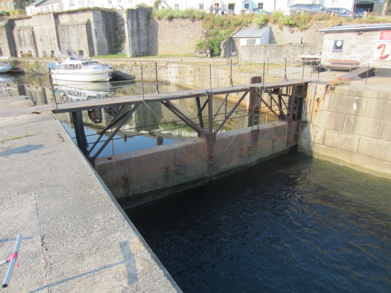
The inner dock is separated from the outer basin by a single steel dock-gate inserted in 1971; a walkway runs along its top. A plaque commemorating the widening of the dock entrance and the new gate is fixed to a building on the east side of the quay.
THE OUTER BASIN: The outer basin comprises an east-west banjo pier connected to the bottom of Charlestown Road outside the Pier House Hotel to the west; and a north-south pier to the east which at its highest point adjoins the south end of Quay Road. Larn & Larn (see Sources) suggests that the floor of the outer basin is constructed of granite blocks which allowed the depth of water to be maintained.
The banjo pier (so named from its long shape with a round head at the harbour mouth), built in 1791, is constructed of granite ashlar with various areas of rebuilding following storm damage. There is a granite ashlar parapet wall along its southern side, and two flights of steps lead to the basin on the north side. Approximately half-way along the inner face of the parapet is a granite memorial stone to Thomas Penhall who died on 20 April 1887. It is unknown in what capacity Penhall served at Charlestown, but as he died at the age of 66 and worked there for 45 years, he must have spent his entire working life at Charlestown. The plaque was paid for by Augustus Crowder at a cost of £7. Along the inner face of the parapet wall are several cast-iron mooring posts set into rectangular recesses, and there are other iron and granite bollards and posts on the quayside. The quayside is largely paved with coarsely-dressed granite blocks and kerbs, and moorstone slabs, with some areas of concrete and cobbles.
The quayside between the inner dock and outer basin on the west side of the harbour has been largely rebuilt, including walling of cast concrete resembling ashlar either side of a steep C20 slipway. The retaining wall to the west, below a public footpath to Crinnis Cliff battery, is constructed of a mix of granite rubble and dressed blocks; it extends to the south where there is a recess for a standpipe (see Ancillary Features, below). To the east of the wall is a slipway with a concrete surface to the western beach, defined along its length by shaped granite blocks. At the west end of the banjo pier are the remains of a winch and the base of a derrick crane.
The north-south pier was built in 1793 and is largely of granite ashlar construction. The outer seawall on the eastern side is constructed of worked Devonian limestone (probably from Plymouth and shipped into the harbour) on a granite-block base with areas of red-brick patching. It is stepped in three sections. The head of the north-south pier is at a higher level, comprising the base of a former limekiln and seawater baths (opened 1833, dem.1875), which is now topped with a granite-rubble parapet wall and is the site of the harbourmaster’s hut. Below this, in the angle between the seawall and limekiln base is a small urinal constructed of granite blocks with the entrance on its west side. At the south end of the pier steps lead up to the seaward head of the pier. A low breakwater is attached at a right-angle to the east side of the pier; it is constructed of granite blocks and is probably contemporary to the earliest phase of the harbour’s construction.
The harbourmaster’s hut was built in around 1885. It is octagonal in plan, probably of killas construction, rendered, with a conical Delabole-slate roof. It has four-pane sash windows and a four-panel door facing landwards. The harbourmaster assisted by a pilot took over the role of dockmaster in 1910 and the role survived until 1999. To the east of the hut is the base and anchoring rings for a flagpole used to signal ships into the outer basin; the flagpole was removed in the 2000s.
To the north-east of the hut is a flight of granite steps with a C20 handrail which lead down to the east beach; at the bottom of the steps is a portal to an arched tunnel leading onto the eastern quay of the inner dock. It was probably rebuilt in the early-C20 and is lined with red brick with substantial granite lintels at the east end. On the seaward side is a slot for shutter (missing) to prevent sea water coming into the dock. It has been suggested that the tunnel was originally built of granite, was square in profile and had a slipway connecting its eastern portal to the beach which was washed away in 1959 (see Allen, in Sources). The steps and sea-facing wall here is constructed of large worked granite blocks, probably part of the rebuilding after a storm in 1892.
To the west of the harbourmaster’s hut a short flight of granite steps with a spearheaded wrought-iron gate leads to the lower quay of the outer basin, which links in turn to the north-south pier. The quay is laid with large cobbles (probably ballast and similar in style to the surviving copper-ore floor by the Rashleigh Arms) with areas of concrete patching and large granite-block kerb stones. A late-C19 lean-to building on the east side of the lower quay is of granite construction with a Delabole rag-slate roof, six-pane window and plank door; inside a single hearth from the earlier limekiln is said to survive. Along the quay edge are several cast-iron bollards, including the upturned barrel of a small cannon. A flight of granite steps leads to the basin.
At the end of both piers at the harbour mouth are iron uprights and bases marking the location of capstans (made at Charlestown Foundry, and now in the beer garden of the Rashleigh Arms), used to bring in and send out ships when the tide or wind was wrong.
THE EASTERN WALL: The retaining wall above the eastern inner-dock quay is constructed principally of granite blocks. At its north end, just below road level, is a concrete portal arch from the 1906-08 underground tramway from Lovering’s Dry. This leads out onto a viewing platform; this was historically part of a late-C19 elevated tramway which ran the length of the eastern side of the harbour, was covered over in around 1908, removed in 1968, and of which some structural aspects of which can still be seen. Moving south, the wall projects slightly with a section of shuttered-concrete construction possibly dating to the 1930s. This interrupts the line of the tramway and appears to have been built to support timber chutes inserted to allow china clay to be tipped from lorries into hoppers on Quay Road directly onto ships. Only one chute survives; it is of timber and steel construction and at the top is a C20 hopper structure built of concrete block with a galvanised lid and gantry which retains a winding mechanism. To the south of this is a pier used to support the tramway, and to the south again are four C19 china-clay cellars which rise from the eastern quay to street level at Quay Road; they were originally taller with a monopitch roof. Substantially built of granite to withstand the weight of the clay, granite is also used for quoins, jambs and lintels. Dried china-clay was tipped into the cellars from the Quay Road side; this was at first done by hand, unloaded from carts, and then from 1906 they were connected to the tramway from Lovering’s dry which ran through the top of the cellars and used small trucks to tip the clay. At the base of the cellars are openings which, with shutters released partway up the cellar and above the openings, allowed a quantity of china clay to be released and loaded onto ships; it is unknown to what extent this mechanism survives. To the south are a further three bays each containing two cellars, of reinforced-concrete construction and probably dating to 1906-08; it appears that they were enclosed in the mid-C20 with steel hatches at their base. Above on Quay Road, each cellar has a rectangular opening (now covered with steel plates) where dried china clay was tipped down into the cellar from small trucks on a continuation of the tramway. Tramway rails survive for a distance of approximately 45 metres in this location. To the south again are stone and concrete piers which supported the tramway. At the far south end are the remains of early-C19 ore hutches, constructed against the retaining wall with two granite-rubble dividing walls; they were used to store consignments of copper ore before shipment. A lean-to building within the hutches was probably constructed in the mid-C20 and is built of concrete block with a corrugated sheet roof, single door and eight-pane window. At the very far end of the eastern wall a tunnel leads to the eastern beach; this is described above under the Outer Basin.
SUBSIDARY FEATURES OF NOTE: this summary provides details of some of the features of note not already mentioned in the description. The omission of other features does not mean that they may not be of interest.
Railings: at the head of the harbour on the western side and on the eastern, lower part of Quay Road are wrought-iron railings, probably forged in the port. They comprise split granite posts (some set in concrete bases) with iron pintails leaded into them, with iron railings bolted into the pintails. In other locations on the eastern wall railing uprights have been fashioned from re-used sections of tramway rails; and throughout the harbour there are other examples of hand-forged railings.
Standpipe locations: prior to the introduction of piped water directly into houses, in the late-C19 Charlestown had a piped water-supply to street standpipes. An example of this is located in the inner dock, where a distinctive dressed-granite frame and lintel is set into the eastern wall.
Charlestown is located on the south coast of Cornwall to the south-east of St Austell. Much has been written about its historic development (see Sources) and more can be found in those publications. Before the construction of a harbour in the late-C18, small-scale import and export was conducted on the beach at Lower Polmear: small schooners and ketches were run up the beach at high tide, loaded to or from horse-drawn wagons, and floated off on the flood. This was dangerous, risky and restrictive. At this time the hamlet comprised a few cottages and a fish cellar, with a farm at Higher Polmear, and it had a population of nine fishermen and their families.
Using money gained from lucrative mining ventures, in 1779 Charles Rashleigh (1747-1823), the tenth child and seventh son of the Rashleighs of Menabilly, purchased 94 acres of land at Duporth, and in 1786 acquired the lease of land at Polmear. He purchased the land, some 600 acres, outright in 1798. At this time there were many small fishing ports on the south coast of Cornwall, but the deep-water harbour at Fowey was too distant from the mines and quarries until the coming of the railways. Seeing the opportunity that a deep-water harbour would create near to the sources of copper and china clay, Rashleigh set about creating a harbour for merchant shipping. In around 1789 Rashleigh sought the advice of civil engineer John Smeaton (1724-1792) to design a new harbour. Smeaton’s first drawing was for a protective outer western pier-arm, for which construction began in 1790 using granite moorstone probably from the Carn Grey area near St Austell. Within a year regular shipments of china clay were being made to the Potteries via Liverpool. Smeaton died in 1792 and it is unknown if the remaining work was carried out to his designs. This included the construction of an eastern pier and breakwater (1793), the deepening of the outer basin, and the excavation of the inner dock back from the line of the beach. The inner dock was used for shipbuilding and repair whilst handling of cargo took place in the outer basin. Gates of Australian ironwood operated by four capstans were added to the inner dock in 1799; they were first replaced in 1855. In 1795 a seven-mile leat was constructed to bring water from the Luxulyan Valley to two reservoirs on the west side of the village. These fed leats in the village, with sluices to the inner dock. Once a year, the inner dock was topped-up to its maximum level and the dock gates opened at low tide to wash away accumulated silt in the outer basin. The inner dock was then drained and cleaned by hand. The leat system also helped to keep the wet dock full in times of drought.
By 1796 the harbour was being written about by travellers such as Hatchett, who described a wet dock with a depth of 15 feet at high water, a rope walk, store houses and fish cellars. His report highlights two of the main exports from the principal industries in the area, china clay and pilchard fishing; the third was copper ore. Copper and clay were heavy products with no end use in the county, so they were exported by sea to South Wales and the Staffordshire Potteries respectively, and pilchards exported to Catholic Mediterranean countries. Although pilchard fishing had been important before the construction of the harbour, Rashleigh developed the industry so that Charlestown became one of the most significant fishing stations along this stretch of coast until the 1870s. Shipbuilding took place in the inner dock and on land to its north comprising a stone and earth ramp; the yard was replaced by an extension to the inner dock in around 1871. Ore hutches were built on the east side of the harbour to store consignments of copper ore before shipment to South Wales. The harbour spurred the growth of the settlement around it and the infrastructure of Charlestown – and its name – was in place by 1799. The entire harbour project was managed by Joseph Dingle who Rashleigh had appointed as Superintendent of Works in 1790.
In 1824, the year after Rashleigh’s death, it was recorded that 4,000 tonnes of china clay were being shipped from Charlestown and for a short time, Charlestown was the principal harbour in Cornwall (and England) for the export of china clay. In 1825 the leasehold of the harbour and village was accepted by Crowder, Sartoris & Co., trading as Charlestown Estates and headed by Augustus Crowder. In 1825 the estate was surveyed by Richard Thomas of Falmouth in order to settle Rashleigh’s will; this is the earliest clear mapping known to survive. The plan shows a long water-filled channel extending inland from the western side of the inner dock; its purpose is not clear as it would have been too narrow for ships. Many of the significant buildings in Charlestown were built during the Crowder’s ownership in the mid-C19.
By 1850 the copper mines in the district were in decline, and Charlestown’s main industry became china clay and stone processing and export. Competition from the new harbours built at Pentewan and Par endured, but Charlestown continued to prosper. By the 1870s its inner dock was so crowded that it was reputed that it was possible to walk from one side to the other across the decks of the ships. In around 1871 the inner dock was extended in length, quarried back into the bedrock creating a quay 317 yards in length. In August 1890 new dock gates were added, their hangings reversed converting the inner dock into a permanent wet dock. The inner dock was segregated into two sides; dirty and clean (or black and white). Coal imported from South Wales for the mining industry was unloaded on the west side of the dock and processed loose blocks of china clay were loaded onto ships on the east side for export. This often caused the china clay to become contaminated, and as such the product was used for cheaper pottery manufacture and paper, paint, cosmetics and other goods. The finer-grade china clays were processed away from Charlestown and transported to the harbour in barrels for use by potteries such as Wedgwood; the full barrels were stored on a cask bank to the north-east of the harbour head. By 1893 the dock was advertised as having space for 18 coasting vessels; imports included coal, timber, limestone, iron and coffee – but the only export was china clay, and in the first half of the C20 this was Charlestown’s dominant industry.
From its earliest days there were floors and cellars around the harbour for storing china clay prior to export. Between 1906 and 1909, wealthy clay-pit owners Lovering & Company constructed a series of buildings to increase their share in its processing and export. The main structures were two china-clay dries: Carbean Clay Dry, and Lovering’s Dry near Polmear Farm. A tunnel from the linhay at Lovering Dry under Quay Road came up into a store, and also out above the harbour. This connected to a late-C19 elevated tramway along the east side of the harbour (later covered over) which connected to chutes to deliver the clay blocks to the waiting ships. The dock gates were replaced yet again in 1911.
Early on in the First World War china clay continued to be exported, but the demand for army recruits resulted in the harbour being closed down. After the war the clay trade was minimal. The dock was limited to only one incoming and one outgoing ship for the duration of the Second World War, with the rest of the dock taken over by the Admiralty as a fitting-out base for minesweepers. New technology meant that the southern china-clay dry and tramway were discontinued in 1968. The inner-dock gates were replaced in 1971 by an electronically-operated single steel gate, hinged along its bottom. At the same time the inner-dock entrance was widened and a concrete pit in the dock floor excavated into which the gate would lie when lowered by an electric winch. The improvements meant that ships of up to 800 tonnes and 58 metres in length could enter the dock. The last import (of fertiliser) came into Charlestown in 1984. Charlestown Estates sold the harbour in 1986. The last shipment of china clay left the harbour in 1999 and the port closed to commercial traffic soon after. Commercial fishing from Charlestown ceased in 2012. The harbour has since been used as a filming location for television and film production. Charlestown is included in the Cornwall and West Devon Mining Landscape World Heritage Site, inscribed by UNESCO in 2006.
Additional historic detail on the functions of each part of the harbour are included in brief in the Description below.
Charlestown Harbour, comprising the inner dock and quays; outer basin and piers; eastern breakwater; and the eastern wall, built from 1790, extended around 1871, and with additions in the early C20, is listed at Grade II* for the following principal reasons:
Architectural interest:
* for its excellent survival as a late-C18 harbour comprising piers, quays, breakwaters and basins, initially constructed from the designs and direction of the eminent engineer John Smeaton;
* the complex retains substantial built evidence of the evolution of china-clay processing from the early C19 and particularly under Lovering & Company from 1906;
* for its integral relationship with the technologically-innovative tunnel complex from Lovering’s dry.
Historic interest:
* within the industrial development of Cornwall, particularly the export of copper ore and china clay, and the import of coal and timber for the extractive industries;
* the harbour is important for its historic national and international trade links;
* as a manifestation of the aspirations of Charles Rashleigh of Menabilly, after whom the harbour was named;
Group value:
* with other listed buildings and structures in Charlestown which represent most of the historic industries and business of the port.
External links are from the relevant listing authority and, where applicable, Wikidata. Wikidata IDs may be related buildings as well as this specific building. If you want to add or update a link, you will need to do so by editing the Wikidata entry.


Other nearby listed buildings
