Approximate Location Map
Large Map »
Latitude: 53.3821 / 53°22'55"N
Longitude: -2.5736 / 2°34'24"W
OS Eastings: 361941
OS Northings: 387404
OS Grid: SJ619874
Mapcode National: GBR BYGB.MB
Mapcode Global: WH98R.F8P1
Plus Code: 9C5V9CJG+RH
Entry Name: 484, Knutsford Road
Listing Date: 4 April 1975
Grade: II
Source: Historic England
Source ID: 1329756
English Heritage Legacy ID: 58806
ID on this website: 101329756
Location: Latchford, Warrington, Cheshire, WA4
County: Warrington
Electoral Ward/Division: Latchford West
Parish: Non Civil Parish
Built-Up Area: Warrington
Traditional County: Cheshire
Lieutenancy Area (Ceremonial County): Cheshire
Church of England Parish: Latchford St James
Church of England Diocese: Chester
Tagged with: Building
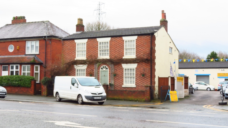
KNUTSFORD ROAD
1.
5150
No 484
SJ 6187 2/82
II
2.
C18 detached house, brick, slate roof, end chimneys, 2 storeys and cellars. Centre
panelled door and round fanlight in round arch, 2 16-paned sash windows on each
floor, and blind panel over door, all with stone sills and lintels.
Listing NGR: SJ6196587398
External links are from the relevant listing authority and, where applicable, Wikidata. Wikidata IDs may be related buildings as well as this specific building. If you want to add or update a link, you will need to do so by editing the Wikidata entry.


Other nearby listed buildings
