Approximate Location Map
Large Map »
Latitude: 53.3468 / 53°20'48"N
Longitude: -1.7384 / 1°44'18"W
OS Eastings: 417514
OS Northings: 383356
OS Grid: SK175833
Mapcode National: GBR JY9Q.FZ
Mapcode Global: WHCCM.84GL
Plus Code: 9C5W87W6+PM
Entry Name: Mile Post at SK 176 834
Listing Date: 24 September 1984
Grade: II
Source: Historic England
Source ID: 1334520
English Heritage Legacy ID: 82544
ID on this website: 101334520
Location: Hope, High Peak, Derbyshire, S33
County: Derbyshire
District: High Peak
Civil Parish: Hope
Built-Up Area: Hope
Traditional County: Derbyshire
Lieutenancy Area (Ceremonial County): Derbyshire
Church of England Parish: Hope St Peter
Church of England Diocese: Derby
Tagged with: Milestone
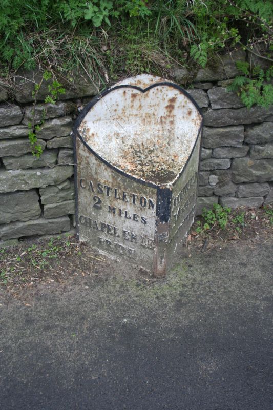
SK 18 SE PARISH OF HOPE STATION ROAD
7/84 (South Side)
Mile post at SK176834
II
Mile post. Early C19. Cast iron. Triangular in plan, the upper part cut away
in concave curve. Inscribed CASTLETON/2 MILES/CHAPEL EN LE/FRITH/8 MILES
SHEFFIELD/14 MILES/HATHERSAGE/4 MILES
Listing NGR: SK1751483356
External links are from the relevant listing authority and, where applicable, Wikidata. Wikidata IDs may be related buildings as well as this specific building. If you want to add or update a link, you will need to do so by editing the Wikidata entry.


Other nearby listed buildings
