Approximate Location Map
Large Map »
Latitude: 51.2845 / 51°17'4"N
Longitude: 1.0708 / 1°4'14"E
OS Eastings: 614235
OS Northings: 158411
OS Grid: TR142584
Mapcode National: GBR TY2.FJJ
Mapcode Global: VHLGF.HZY5
Plus Code: 9F3373MC+R8
Entry Name: 5, Forty Acres Road
Listing Date: 7 September 1973
Grade: II
Source: Historic England
Source ID: 1336820
English Heritage Legacy ID: 170611
ID on this website: 101336820
Location: St Dunstan's, Canterbury, Kent, CT2
County: Kent
District: Canterbury
Electoral Ward/Division: St Stephen's
Parish: Non Civil Parish
Built-Up Area: Canterbury
Traditional County: Kent
Lieutenancy Area (Ceremonial County): Kent
Tagged with: Building
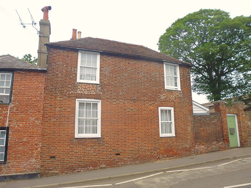
1.
944 FORTY ACRES ROAD
(South West Side)
No 5
TR 1458 SW 1/495
II GV
2.
Early C19. 2 storeys red brick, Hipped old tiled roof. 2 sashes set in
moulded architraves with some glazing bars intact.
Nos 2, 4 & 5 form a group.
Listing NGR: TR1423458413
External links are from the relevant listing authority and, where applicable, Wikidata. Wikidata IDs may be related buildings as well as this specific building. If you want to add or update a link, you will need to do so by editing the Wikidata entry.


Other nearby listed buildings
