Approximate Location Map
Large Map »
Latitude: 51.2798 / 51°16'47"N
Longitude: 1.0827 / 1°4'57"E
OS Eastings: 615084
OS Northings: 157922
OS Grid: TR150579
Mapcode National: GBR TY2.QK3
Mapcode Global: VHLGM.Q367
Plus Code: 9F3373HM+W3
Entry Name: Christchurch Cathedral
Listing Date: 3 December 1949
Grade: I
Source: Historic England
Source ID: 1336823
English Heritage Legacy ID: 170528
Also known as: Cathedral and Metropolitical Church of Christ at Canterbury
ID on this website: 101336823
Location: Christ Church Cathedral, Canterbury, Kent, CT1
County: Kent
District: Canterbury
Electoral Ward/Division: Westgate
Parish: Non Civil Parish
Built-Up Area: Canterbury
Traditional County: Kent
Lieutenancy Area (Ceremonial County): Kent
Tagged with: Anglican or episcopal cathedral Romanesque architecture English Gothic architecture Norman architecture Gothic art
This list entry was subject to a Minor Enhancement on 20/05/2020
944
THE CATHEDRAL PRECINCTS
Christchurch Cathedral
TR 1557 NW 5/1
3.12.49
I
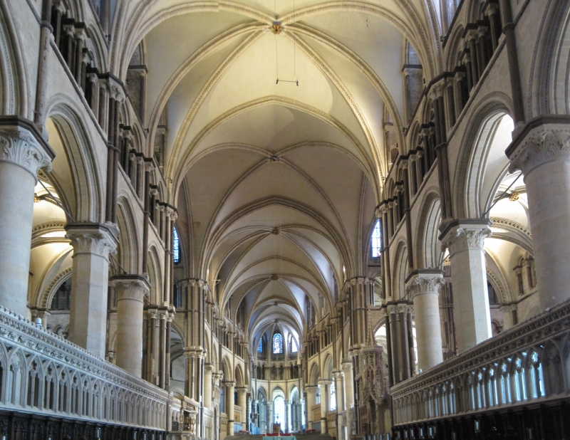
THE CATHEDRAL PRECINCTS Christchurch Cathedral TR 1557 NW 5/1 3.12.49 I The original church on the site was one built for Roman Christians. St Augustine reconsecrated the church in 602 AD. The present building is a mixture of building styles from the C11 to the present day. The exterior is built mainly of Caen stone. On the East side some Romanesque arcading is visible though most of the stone work dates from 1175-1184, built by William of Sens and William the Englishman, or from the late C14 to Mid C15 rebuilding. The south-west tower was built in 1424-1434, the north-west tower is a replica of this built in 1832-1841. The central "Bell Harry" tower of brick faced with stone was built between 1494 and 1503 and is one of the first brick structures. 7 bay Nave with clerestory, built between 1378 - 1410. Choir and Corona built by William of Sens and William the Englishman. Very fine early Romanesque crypt of 10 bays and Chapel of Our Lady of the Undercroft.
Listing NGR: TR1511457922
External links are from the relevant listing authority and, where applicable, Wikidata. Wikidata IDs may be related buildings as well as this specific building. If you want to add or update a link, you will need to do so by editing the Wikidata entry.


Other nearby listed buildings
