Latitude: 50.8995 / 50°53'58"N
Longitude: -1.4066 / 1°24'23"W
OS Eastings: 441822
OS Northings: 111285
OS Grid: SU418112
Mapcode National: GBR RQC.K4
Mapcode Global: FRA 76YQ.MT8
Plus Code: 9C2WVHXV+R8
Entry Name: King John's Palace (Situated to West of Tudor House Museum)
Listing Date: 14 July 1953
Last Amended: 8 October 1981
Grade: I
Source: Historic England
Source ID: 1339942
English Heritage Legacy ID: 135730
ID on this website: 101339942
Location: Southampton, Hampshire, SO14
County: City of Southampton
Electoral Ward/Division: Bargate
Parish: Non Civil Parish
Built-Up Area: Southampton
Traditional County: Hampshire
Lieutenancy Area (Ceremonial County): Hampshire
Church of England Parish: Southampton City Centre St Mary
Church of England Diocese: Winchester
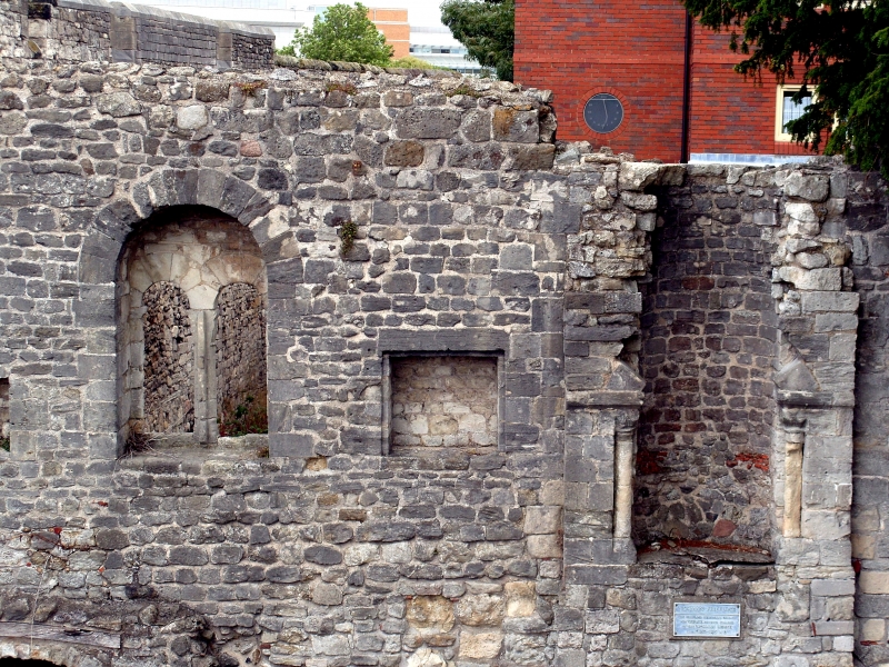
1. BLUE ANCHOR LANE
5239
King John's Palace
(situated to west
of Tudor House Museum)
(formerly listed under
Bugle Street)
SU 4111 3/38 14.7.53
I GV
2.
Circa 1170. Early C14 and mid-C14. Remains of a merchant's house, the ground
floor originally used for storage and the upper floor as living quarters.
It originally stood on the quayside. The west wall was incorporated in the
city defences after the French raid of 1338. The roof was removed in the
early C20. Two storeys stone. North and west arcades have original C12 windows
of 2 round-headed lights in round-arched frames. The west facade also has
the blocked archways which led directly on to the quays, one C12 round-headed
arch and 2 early C14 segmental-headed arches. Within these blocked arches
are 2 vertical defensive slits of the C14 defences which may be the earliest
surviving gunports in Britain. Parts of the original stone fireplace on the
north side of the first floor survive, including both jambs, with inset shafts
and scalloped capitals. Against the east wall is a late Norman chimney of
circa 1200, removed from No 79A High Street, in the form of a long round stone
shaft rising from a square base. This house is one of the most complete of
the larger C12 town houses surviving in the country.
Scheduled as an ancient monument.
Listing NGR: SU4255313582
External links are from the relevant listing authority and, where applicable, Wikidata. Wikidata IDs may be related buildings as well as this specific building. If you want to add or update a link, you will need to do so by editing the Wikidata entry.


Other nearby listed buildings