Latitude: 51.501 / 51°30'3"N
Longitude: -0.1517 / 0°9'6"W
OS Eastings: 528388
OS Northings: 179625
OS Grid: TQ283796
Mapcode National: GBR BJ.33
Mapcode Global: VHGQZ.BJ5P
Plus Code: 9C3XGR2X+98
Entry Name: 1-4, Halkin Street SW1
Listing Date: 1 December 1987
Grade: II
Source: Historic England
Source ID: 1357087
English Heritage Legacy ID: 210014
ID on this website: 101357087
Location: Hyde Park Corner, Westminster, London, SW1X
County: London
District: City of Westminster
Electoral Ward/Division: Knightsbridge and Belgravia
Parish: Non Civil Parish
Built-Up Area: City of Westminster
Traditional County: Middlesex
Lieutenancy Area (Ceremonial County): Greater London
Church of England Parish: St Paul Knightsbridge
Church of England Diocese: London
Tagged with: Building
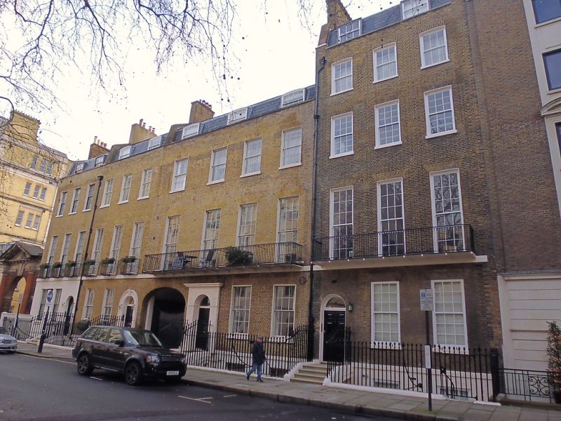
TQ 2879 NW CITY OF WESTMINSTER HALKIN STREET, SW1
88/36 (south-east side)
Nos 1 to 4 (consec)
GV II
Row of houses. Early C19. Yellow brick. Slate mansard roofs. 3 storeys (No 4
has 4 storeys) plus attics and basements. Each house 3 windows wide (No 3 is 4
windows wide). Round headed entrances, Nos 2 and 3 with stucco surrounds.
Various panelled doors. Stuccoed ground floor to No 1. Segmental arched
carriageway to right side of No 3. Windows with square gauged heads. Sashes
(casements to No 4). Mainly small panes. Wrought iron. "Gothick" balconies to
first floor. Parapets. Cast iron area railings.
Listing NGR: TQ2838879625
External links are from the relevant listing authority and, where applicable, Wikidata. Wikidata IDs may be related buildings as well as this specific building. If you want to add or update a link, you will need to do so by editing the Wikidata entry.


Other nearby listed buildings