Approximate Location Map
Large Map »
Latitude: 51.3589 / 51°21'31"N
Longitude: 0.0716 / 0°4'17"E
OS Eastings: 544334
OS Northings: 164236
OS Grid: TQ443642
Mapcode National: GBR NT.4QY
Mapcode Global: VHHPB.637M
Plus Code: 9F32935C+GM
Entry Name: 20, Church Road
Listing Date: 29 June 1973
Grade: II
Source: Historic England
Source ID: 1359348
English Heritage Legacy ID: 358402
ID on this website: 101359348
Location: Farnborough, Bromley, London, BR6
County: London
District: Bromley
Electoral Ward/Division: Farnborough and Crofton
Parish: Non Civil Parish
Built-Up Area: Bromley
Traditional County: Kent
Lieutenancy Area (Ceremonial County): Greater London
Church of England Parish: Farnborough St Giles
Church of England Diocese: Rochester
Tagged with: Building
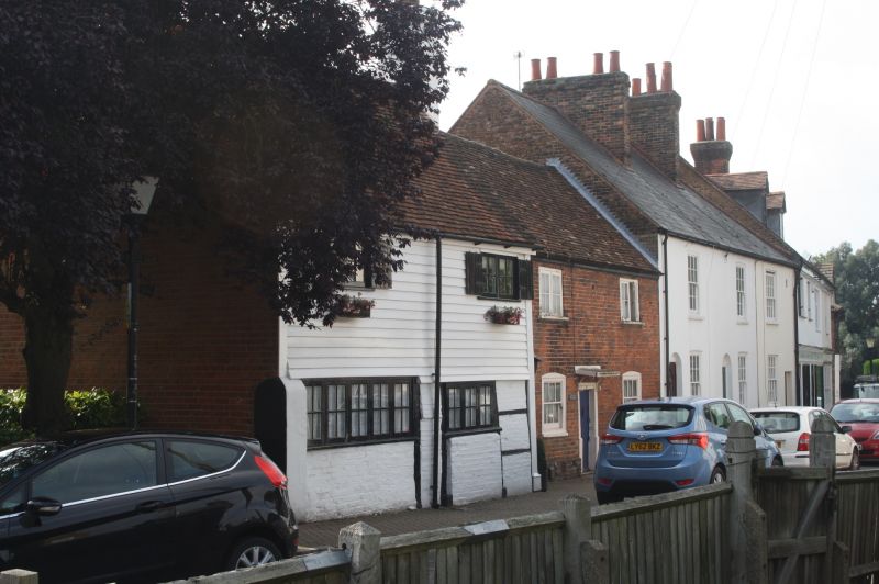
CHURCH ROAD, FARNBOROUGH
1.
4407 (South-West Side)
No 20
TQ 46 SW 12/162
II
2.
C17. 2 storeys. 1st floor weatherboarded. Ground floor brick with some
revealed half timbers. 2 casement windows of 2 lights on 1st floor. 5
and 3 lights on ground floors. Tiled roof slopes to rear. Side is faced
with brick.
Listing NGR: TQ4009669300
External links are from the relevant listing authority and, where applicable, Wikidata. Wikidata IDs may be related buildings as well as this specific building. If you want to add or update a link, you will need to do so by editing the Wikidata entry.


Other nearby listed buildings
