Approximate Location Map
Large Map »
Latitude: 51.5219 / 51°31'18"N
Longitude: -1.1346 / 1°8'4"W
OS Eastings: 460135
OS Northings: 180685
OS Grid: SU601806
Mapcode National: GBR 920.FZF
Mapcode Global: VHCZ2.900N
Plus Code: 9C3WGVC8+Q4
Entry Name: Barn and Stables Approximately 15 Metres East of the Old Farmhouse
Listing Date: 16 August 1985
Grade: II
Source: Historic England
Source ID: 1059557
English Heritage Legacy ID: 247289
ID on this website: 101059557
Location: Goring, South Oxfordshire, RG8
County: Oxfordshire
District: South Oxfordshire
Civil Parish: Goring-on-Thames
Built-Up Area: Goring
Traditional County: Oxfordshire
Lieutenancy Area (Ceremonial County): Oxfordshire
Church of England Parish: Goring
Church of England Diocese: Oxford
Tagged with: Barn Thatched barn
GORING STATION ROAD
SU6080 (North side)
Goring-on-Thames
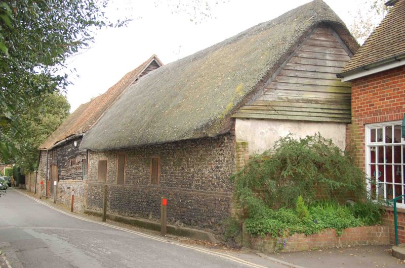
12/72 Barn and stables approx. 15m.
E of The Old Farmhouse
GV II
Barn. Probably late C17. Flint base with brick bands and quoins; large timber
framing; weatherboarding; plain tile roof; 5-bay barn. Central plank doors.
Queen post roof. Stables to right; flint walls with brick dressings; thatch
roof. 3 probably C20 openings.
Listing NGR: SU6013580685
External links are from the relevant listing authority and, where applicable, Wikidata. Wikidata IDs may be related buildings as well as this specific building. If you want to add or update a link, you will need to do so by editing the Wikidata entry.


Other nearby listed buildings
