Approximate Location Map
Large Map »
Latitude: 53.194 / 53°11'38"N
Longitude: -2.892 / 2°53'31"W
OS Eastings: 340504
OS Northings: 366700
OS Grid: SJ405667
Mapcode National: GBR 7B.2S01
Mapcode Global: WH887.KZ28
Plus Code: 9C5V54V5+J6
Entry Name: Part of City Wall from Northgate to Phoenix Tower
Listing Date: 28 July 1955
Last Amended: 6 August 1998
Grade: I
Source: Historic England
Source ID: 1376136
English Heritage Legacy ID: 470126
ID on this website: 101376136
Location: Newtown, Cheshire West and Chester, Cheshire, CH1
County: Cheshire West and Chester
Electoral Ward/Division: Chester City
Parish: Non Civil Parish
Built-Up Area: Chester
Traditional County: Cheshire
Lieutenancy Area (Ceremonial County): Cheshire
Church of England Parish: Chester St Oswald and St Thomas of Canterbury
Church of England Diocese: Chester
Tagged with: City walls
CHESTER CITY (IM)
SJ4066NW CITY WALLS
595-1/1/109 Part of City Wall from Northgate to
28/07/55 Phoenix Tower
(Formerly Listed as:
City Walls & Towers incl.
foundations of SE angle Roman
Fortress wall & tower)
GV I
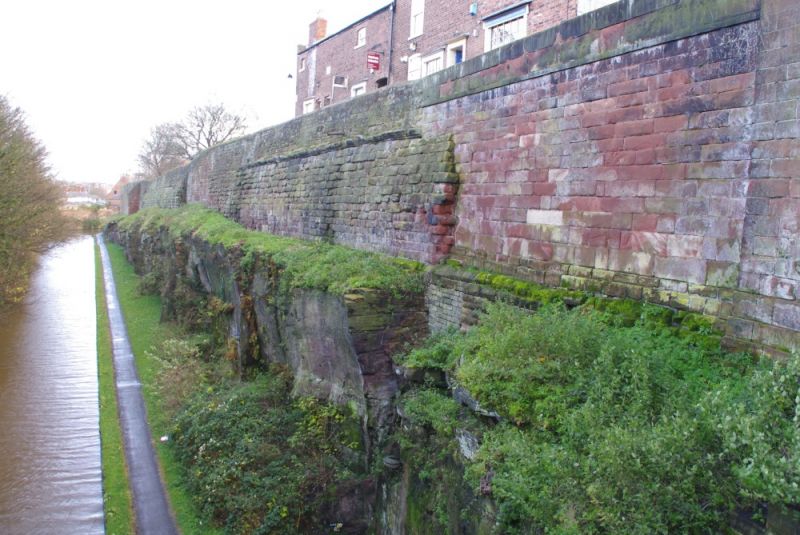
Length of City Walls comprising masonry of the east half of
the north wall of the Roman legionary fortress. Late C1 to
early C2 and possibly later, medieval wall late C11 to early
C12 converted to a raised promenade 1702 to 1708 and
spasmodically repaired. Purple-grey Bunter sandstone Roman
ashlar and medieval and later softer red sandstone coursed
rubble. The features of exceptional interest are 2 full-height
portions of the probably Hadrianic Roman wall-face to the then
turf rampart, behind. The west portion of the masonry is based
on bedrock, up to 13 courses high and 35 ashlar stones long
and has the moulded Roman cornice immediately beneath the
former Roman and, at the same level, present parapet. The east
portion is up to 11 courses high and 42 ashlar stones long.
The wall faces the Shropshire Union Canal in a rock-cut
deepening of the former Roman and medieval ditch. There may be
some Roman ashlar in the canted north-east corner of the wall
adjacent to Phoenix Tower (qv). The Roman wall-face is
battered, supposedly having gradually moved back as the turf
rampart behind it contracted. The medieval and post medieval
masonry shows numerous repairs.
This length of the City Wall is approx 375m long and 2m wide.
(Strickland TJ: Roman Chester: Nelson: 1984-1986: PASSIM;
Cheshire Sites and Monuments Record: Collens J: Chester City:
3000/1/7; The Buildings of England: Pevsner N & Hubbard E:
Cheshire: 1971-: 155).
Listing NGR: SJ4050466699
External links are from the relevant listing authority and, where applicable, Wikidata. Wikidata IDs may be related buildings as well as this specific building. If you want to add or update a link, you will need to do so by editing the Wikidata entry.


Other nearby listed buildings
