Approximate Location Map
Large Map »
Latitude: 51.5086 / 51°30'30"N
Longitude: -0.1037 / 0°6'13"W
OS Eastings: 531699
OS Northings: 180554
OS Grid: TQ316805
Mapcode National: GBR NF.WD
Mapcode Global: VHGR0.5B1W
Plus Code: 9C3XGV5W+CG
Entry Name: Southern Abutment to Former West Blackfriars and St Pauls Rail Bridge
Listing Date: 24 August 1995
Grade: II
Source: Historic England
Source ID: 1376596
English Heritage Legacy ID: 470601
ID on this website: 101376596
Location: North Southwark, Southwark, London, SE1
County: London
District: Southwark
Electoral Ward/Division: Cathedrals
Parish: Non Civil Parish
Built-Up Area: Southwark
Traditional County: Surrey
Lieutenancy Area (Ceremonial County): Greater London
Church of England Parish: Southwark Christ Church
Church of England Diocese: Southwark
Tagged with: Bridge
TQ3180
636-1/1/874
24/08/95
SOUTHWARK
BLACKFRIARS ROAD
Southern abutment to former West Blackfriars and St Paul's Rail Bridge
GV
II
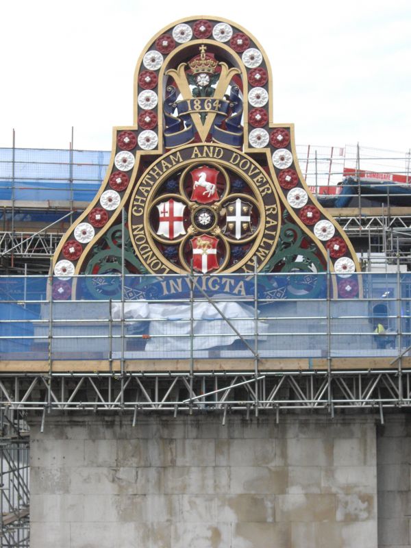
Abutment. 1862-64. By Joseph Cubitt. For the London, Chatham
and Dover Railway Company. Abutments of stone faced with
Portland stone from Charles Labelye's Westminster Bridge of
1738-49.
HISTORICAL NOTE: built for the London, Chatham and Dover
Railway Company to support the line on the Beckenham to
Ludgate Hill route. As the bridge was to form part of the
company's Blackfriars Station it was given good cast-iron
ornament; the large shields flanking the way on the Southwark
side bear the company's crest and title in full. These were
restored c1990. The abutment to the south shore falls within
the London Borough of Southwark. Joseph Cubitt designed
Blackfriars Road Bridge to the west (see City of London), and
with it this forms a group.
Listing NGR: TQ3169980554
External links are from the relevant listing authority and, where applicable, Wikidata. Wikidata IDs may be related buildings as well as this specific building. If you want to add or update a link, you will need to do so by editing the Wikidata entry.


Other nearby listed buildings
