Latitude: 52.2468 / 52°14'48"N
Longitude: 0.7125 / 0°42'44"E
OS Eastings: 585272
OS Northings: 264421
OS Grid: TL852644
Mapcode National: GBR QF0.0Z7
Mapcode Global: VHKD4.9SJH
Plus Code: 9F426PW6+PX
Entry Name: 5, Brentgovel Street
Listing Date: 7 May 1981
Grade: II
Source: Historic England
Source ID: 1377007
English Heritage Legacy ID: 466655
ID on this website: 101377007
Location: Bury St Edmunds, West Suffolk, IP33
County: Suffolk
District: West Suffolk
Civil Parish: Bury St Edmunds
Built-Up Area: Bury St Edmunds
Traditional County: Suffolk
Lieutenancy Area (Ceremonial County): Suffolk
Church of England Parish: Bury St Edmunds St John the Evangelist
Church of England Diocese: St.Edmundsbury and Ipswich
Tagged with: Building
BURY ST EDMUNDS
TL8564SW BRENTGOVEL STREET
639-1/7/193 (North side)
07/05/81 No.5
II
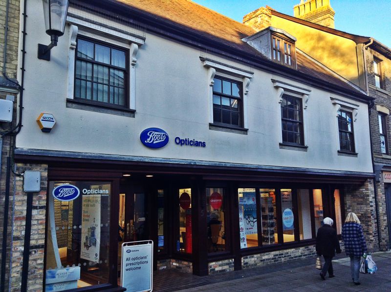
Shop. Late C16; exterior and extensions at the rear of 1970s
and 1980s. Timber-framed and rendered; C20 plaintiles.
EXTERIOR: 2 storeys; the original front range in 2 bays with
an end chimney-stack. Exterior with a wide jetty, sash windows
to the upper storey, and heavy woodwork in traditional style
to the shop front.
INTERIOR: on the ground storey the main beam and the
cross-beam in front of the chimney-stack have double
roll-mouldings. On the upper storey the frame is exposed, and
complete on the rear and west side wall. Close-studding with
arched braces and housings for two 3-light diamond-mullioned
windows along the front wall. Chamfered main beams, joists on
edge. A plain timber lintel to the open fireplace. An
edge-halved and bridled scarf joint in the rear wallplate.
Clasped purlin roof, visible because the plaster between the
joists has been removed, in 3 bays with one collar missing.
Listing NGR: TL8527264421
External links are from the relevant listing authority and, where applicable, Wikidata. Wikidata IDs may be related buildings as well as this specific building. If you want to add or update a link, you will need to do so by editing the Wikidata entry.


Other nearby listed buildings