Latitude: 51.2113 / 51°12'40"N
Longitude: -2.6467 / 2°38'48"W
OS Eastings: 354924
OS Northings: 145988
OS Grid: ST549459
Mapcode National: GBR MN.3WVT
Mapcode Global: VH89S.2TN8
Plus Code: 9C3V6963+G8
Entry Name: 11, New Street
Listing Date: 12 November 1953
Grade: II
Source: Historic England
Source ID: 1383043
English Heritage Legacy ID: 483461
ID on this website: 101383043
Location: Wells, Somerset, BA5
County: Somerset
District: Mendip
Civil Parish: Wells
Built-Up Area: Wells
Traditional County: Somerset
Lieutenancy Area (Ceremonial County): Somerset
Tagged with: Building
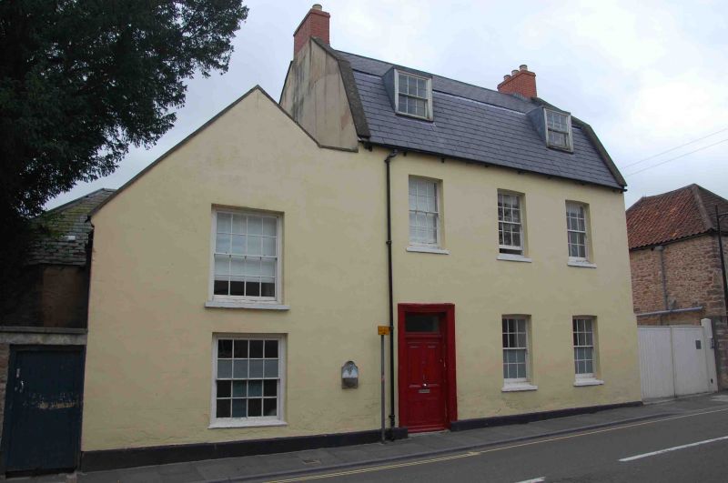
WELLS
ST5445 NEW STREET
662-1/7/179 (West side)
12/11/53 No.11
GV II
House. Late C18/early C19. Local stone rubble rendered on
front elevation, with ashlar dressings, Welsh slate Mansard
roof between coped gables, brick end chimney stacks.
EXTERIOR: 2 storeys with attics, 3 bays, with extensions on
south side. Plinth. Sash windows of 12 panes in plain openings
with segmental-arched heads, to lower bay 1 a C19 pattern door
with rectangular fanlight set in stone architrave. Bays 1 and
3 have flat-roofed dormers with small 12-pane sash windows.
Annexe left of bay 1 of single bay, single-storey with attic,
with gable to road having 16-pane sashes to both floors, the
upper larger. Additional lower extension to rear of this set
parallel with the street.
INTERIOR: not inspected.
Listing NGR: ST5492445988
External links are from the relevant listing authority and, where applicable, Wikidata. Wikidata IDs may be related buildings as well as this specific building. If you want to add or update a link, you will need to do so by editing the Wikidata entry.


Other nearby listed buildings