Latitude: 51.2109 / 51°12'39"N
Longitude: -2.6467 / 2°38'48"W
OS Eastings: 354920
OS Northings: 145942
OS Grid: ST549459
Mapcode National: GBR MN.3WTP
Mapcode Global: VH89S.2TML
Plus Code: 9C3V6963+98
Entry Name: 7, New Street
Listing Date: 12 November 1953
Grade: II
Source: Historic England
Source ID: 1383038
English Heritage Legacy ID: 483456
ID on this website: 101383038
Location: Wells, Somerset, BA5
County: Somerset
District: Mendip
Civil Parish: Wells
Built-Up Area: Wells
Traditional County: Somerset
Lieutenancy Area (Ceremonial County): Somerset
Tagged with: Building
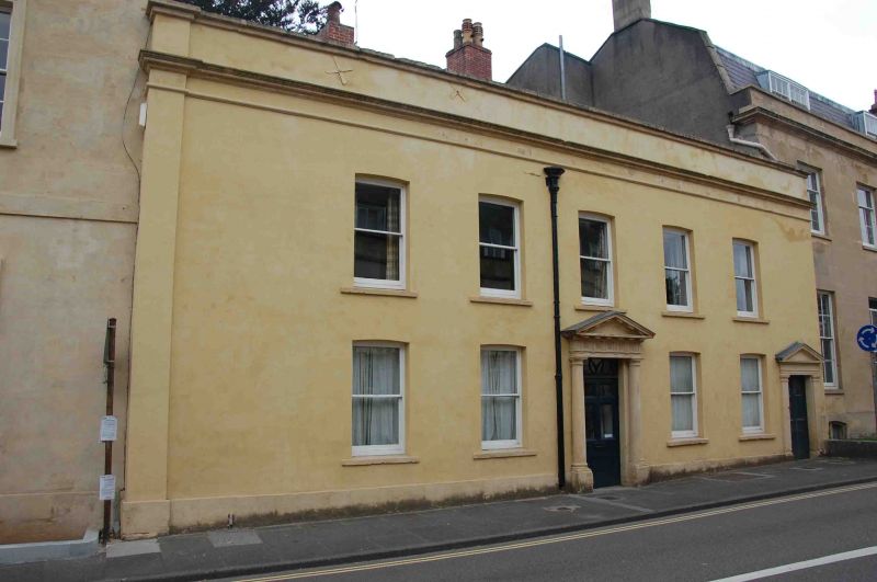
WELLS
ST5445 NEW STREET
662-1/7/174 (West side)
12/11/53 No.7
GV II
House in terrace. C18. Rendered and colourwashed over rubble,
roof not visible from behind parapet, brick chimney stack.
EXTERIOR: 2 storeys, 5 bays. plinth, cornice, plain parapet.
Plain sash windows in plain segmental-arched openings to all
but lower bay 3, which has a 6-panel door partially adopted
with glazing with ornamental rectangular fanlight over, framed
with a stone doorcase of attached Doric columns on plinth
carrying enriched triglyph frieze and dentilled pediment; to
right of bay 5, a 6-panel door in simpler surround of Doric
pilasters, plain entablature and pediment. Between bays 2 and
three is a lead downpipe and stackhead of C18 pattern.
INTERIOR: not inspected.
Listing NGR: ST5492045942
External links are from the relevant listing authority and, where applicable, Wikidata. Wikidata IDs may be related buildings as well as this specific building. If you want to add or update a link, you will need to do so by editing the Wikidata entry.


Other nearby listed buildings