Approximate Location Map
Large Map »
Latitude: 52.5371 / 52°32'13"N
Longitude: -2.8084 / 2°48'30"W
OS Eastings: 345265
OS Northings: 293552
OS Grid: SO452935
Mapcode National: GBR BG.F794
Mapcode Global: VH75V.8HNF
Plus Code: 9C4VG5PR+RJ
Entry Name: 63, High Street
Listing Date: 15 March 1974
Last Amended: 29 February 2000
Grade: II
Source: Historic England
Source ID: 1383294
English Heritage Legacy ID: 483712
ID on this website: 101383294
Location: Church Stretton, Shropshire, SY6
County: Shropshire
Civil Parish: Church Stretton
Built-Up Area: Church Stretton
Traditional County: Shropshire
Lieutenancy Area (Ceremonial County): Shropshire
Church of England Parish: Church Stretton
Church of England Diocese: Hereford
Tagged with: Building
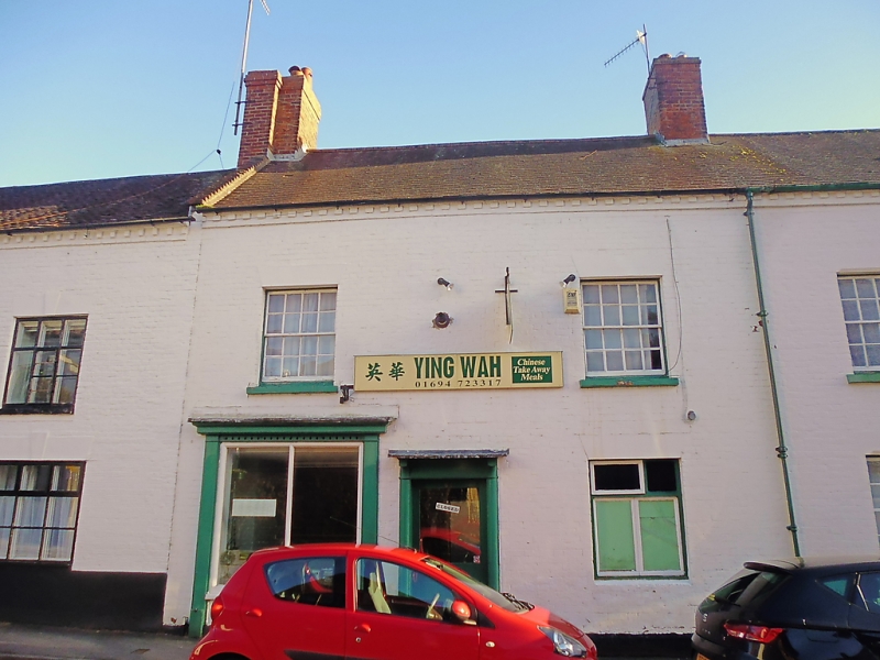
CHURCH STRETTON
SO4593 HIGH STREET
1312-1/13/71 (East side)
15/03/74 No.63
(Formerly Listed as:
HIGH STREET
(East side)
Nos.59-65 (Odd))
GV II
House, now shop. C18. Painted brick. Tiled roof with dentilled
brick eaves. Axial brick ridge stack. Part of terrace of
buildings running parallel to the road.
EXTERIOR: street front is a 2-storey, 2-window range of 8/8
sashes with painted ashlar lintels; replaced at ground floor
with C19 inserted shop front to left and central moulded wood
pilaster doorcase with bracketed hood and C20 glazed door; C20
casement to right.
INTERIOR: not inspected.
Listing NGR: SO4526893551
External links are from the relevant listing authority and, where applicable, Wikidata. Wikidata IDs may be related buildings as well as this specific building. If you want to add or update a link, you will need to do so by editing the Wikidata entry.


Other nearby listed buildings
