Approximate Location Map
Large Map »
Latitude: 52.5373 / 52°32'14"N
Longitude: -2.8082 / 2°48'29"W
OS Eastings: 345276
OS Northings: 293578
OS Grid: SO452935
Mapcode National: GBR BG.F7B4
Mapcode Global: VH75V.8HR8
Plus Code: 9C4VG5PR+WP
Entry Name: 57, High Street
Listing Date: 15 March 1974
Grade: II
Source: Historic England
Source ID: 1383291
English Heritage Legacy ID: 483709
ID on this website: 101383291
Location: Church Stretton, Shropshire, SY6
County: Shropshire
Civil Parish: Church Stretton
Built-Up Area: Church Stretton
Traditional County: Shropshire
Lieutenancy Area (Ceremonial County): Shropshire
Church of England Parish: Church Stretton
Church of England Diocese: Hereford
Tagged with: Building
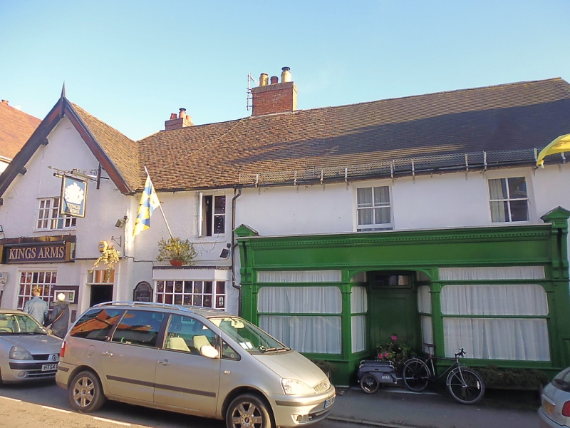
CHURCH STRETTON
SO4593 HIGH STREET
1312-1/13/68 (East side)
15/03/74 No.57
GV II
Shop. Early C19 with earlier core. Painted roughcast render
with projecting ashlar eaves. Plain-tile roof. Lateral brick
ridge stack. Rectangular plan parallel to street.
EXTERIOR: 2 storeys. Street front with 2 C20 sashes over mid
C19 double-fronted shop display window with central splayed
doorway and C20 glazed panelled door.
INTERIOR: not inspected.
Forms a group with other buildings in High Street and included
for group value.
Listing NGR: SO4527693578
External links are from the relevant listing authority and, where applicable, Wikidata. Wikidata IDs may be related buildings as well as this specific building. If you want to add or update a link, you will need to do so by editing the Wikidata entry.


Other nearby listed buildings
