Approximate Location Map
Large Map »
Latitude: 52.5372 / 52°32'13"N
Longitude: -2.8083 / 2°48'29"W
OS Eastings: 345273
OS Northings: 293568
OS Grid: SO452935
Mapcode National: GBR BG.F792
Mapcode Global: VH75V.8HQB
Plus Code: 9C4VG5PR+VM
Entry Name: 59, High Street
Listing Date: 15 March 1974
Last Amended: 29 February 2000
Grade: II
Source: Historic England
Source ID: 1383292
English Heritage Legacy ID: 483710
ID on this website: 101383292
Location: Church Stretton, Shropshire, SY6
County: Shropshire
Civil Parish: Church Stretton
Built-Up Area: Church Stretton
Traditional County: Shropshire
Lieutenancy Area (Ceremonial County): Shropshire
Church of England Parish: Church Stretton
Church of England Diocese: Hereford
Tagged with: Building
CHURCH STRETTON
SO4593 HIGH STREET
1312-1/13/69 (East side)
15/03/74 No.59
(Formerly Listed as:
HIGH STREET
(East side)
Nos.59-65 (Odd))
GV II
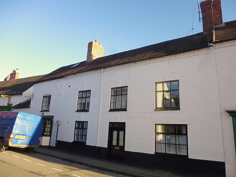
House, now restaurant. C18. Painted brick with brick corbelled
eaves. Plain-tile roof with C20 roof-light.
EXTERIOR: 2 storeys to right and single-storey and attic to
left. Street front with single 2-light casement in brick
segmental arched opening. Projecting bay window to right,
central C20 glazed panelled door, C20 multi-pane bow window to
left at ground floor.
INTERIOR: not inspected.
Forms a group with other buildings in High Street and included
for group value.
Listing NGR: SO4527393568
External links are from the relevant listing authority and, where applicable, Wikidata. Wikidata IDs may be related buildings as well as this specific building. If you want to add or update a link, you will need to do so by editing the Wikidata entry.


Other nearby listed buildings
