Approximate Location Map
Large Map »
Latitude: 52.313 / 52°18'46"N
Longitude: -2.6073 / 2°36'26"W
OS Eastings: 358698
OS Northings: 268496
OS Grid: SO586684
Mapcode National: GBR BQ.WGT9
Mapcode Global: VH84K.R4H5
Plus Code: 9C4V897V+63
Entry Name: Turnpike Cottage
Listing Date: 29 February 2000
Grade: II
Source: Historic England
Source ID: 1383429
English Heritage Legacy ID: 483847
ID on this website: 101383429
Location: Burford, Shropshire, WR15
County: Shropshire
Civil Parish: Burford
Traditional County: Shropshire
Lieutenancy Area (Ceremonial County): Shropshire
Church of England Parish: Burford, 3rd Portion
Church of England Diocese: Hereford
Tagged with: Cottage
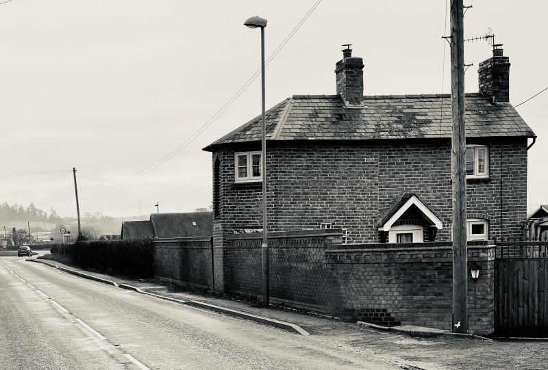
BURFORD
SO56NE A 456
582-1/8/15 (South side)
Turnpike Cottage
GV II
Toll house, now house. Late C18. Brick. Hipped and gabled
slate roof. 2 central brick ridge stacks. Range at right
angles to road with canted end bay to road, with gable
extension wing to left.
EXTERIOR: 2 storeys. Street front with central first-floor
niche with pointed head flanked by canted bay faces each with
2-light casements with painted keyed lintels. Right return
with central boarded door and 3-light casements at both floors
to right, all with brick segmental lintels. Left side partly
covered with projecting wing to right and with 2-light
casement to left with brick segmental lintel. Wing with
casements with painted keyed lintels to street side and gable
end.
INTERIOR: not inspected.
Listing NGR: SO5869868496
External links are from the relevant listing authority and, where applicable, Wikidata. Wikidata IDs may be related buildings as well as this specific building. If you want to add or update a link, you will need to do so by editing the Wikidata entry.


Other nearby listed buildings
