Approximate Location Map
Large Map »
Latitude: 54.2548 / 54°15'17"N
Longitude: -2.3425 / 2°20'33"W
OS Eastings: 377780
OS Northings: 484400
OS Grid: SD777844
Mapcode National: GBR DM27.NJ
Mapcode Global: WH94L.ZBN1
Plus Code: 9C6V7M34+WX
Entry Name: Dent Head Viaduct
Listing Date: 18 October 1999
Grade: II
Source: Historic England
Source ID: 1383847
English Heritage Legacy ID: 484279
ID on this website: 101383847
Location: Westmorland and Furness, Cumbria, LA10
County: Cumbria
District: South Lakeland
Civil Parish: Dent
Traditional County: Yorkshire
Lieutenancy Area (Ceremonial County): Cumbria
Church of England Parish: Dent with Cowgill
Church of England Diocese: Carlisle
DENT
SD78SE DENTDALE
162-1/15/46 (North side)
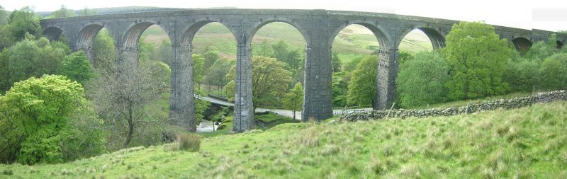
Dent Head Viaduct
GV II
Railway viaduct carrying Settle to Carlisle railway line over
Fell End Gill. c1869-75, for the Midland Railway Company,
Chief Engineer John Crossley, resident engineer J.Underwood.
Rock-faced sandstone in massive blocks, mostly coursed but
some snecked, with brick soffits to the arches. Slightly
curved line on north-south axis. Ten tall round-headed arches
on battered rectangular piers, that in the centre broader than
the others and with a broad tapered pilaster; short
cavetto-moulded imposts at the springing of the arches,
rusticated voussoirs (now with 3 tie-plates to each arch), a
moulded string course, and parapets with rounded coping. Forms
a very striking feature at the head of Dentdale, and an
interesting contrast with the Pack Saddle Bridge approx. 10m
east (qv).
Listing NGR: SD7778084400
External links are from the relevant listing authority and, where applicable, Wikidata. Wikidata IDs may be related buildings as well as this specific building. If you want to add or update a link, you will need to do so by editing the Wikidata entry.


Other nearby listed buildings
