Approximate Location Map
Large Map »
Latitude: 54.2678 / 54°16'4"N
Longitude: -2.3531 / 2°21'11"W
OS Eastings: 377101
OS Northings: 485852
OS Grid: SD771858
Mapcode National: GBR DM02.CW
Mapcode Global: WH94D.TZNL
Plus Code: 9C6V7J9W+4Q
Entry Name: Lime Kiln Built into Hillside Approximately 50 Metres South of Stonehouse Bridge
Listing Date: 14 June 1984
Grade: II
Source: Historic England
Source ID: 1383943
English Heritage Legacy ID: 484375
ID on this website: 101383943
Location: Stone House, Westmorland and Furness, Cumbria, LA10
County: Cumbria
District: South Lakeland
Civil Parish: Dent
Traditional County: Yorkshire
Lieutenancy Area (Ceremonial County): Cumbria
Church of England Parish: Dent with Cowgill
Church of England Diocese: Carlisle
Tagged with: Lime kiln
DENT
SD78NE DENTDALE
162-1/12/146 (South side)
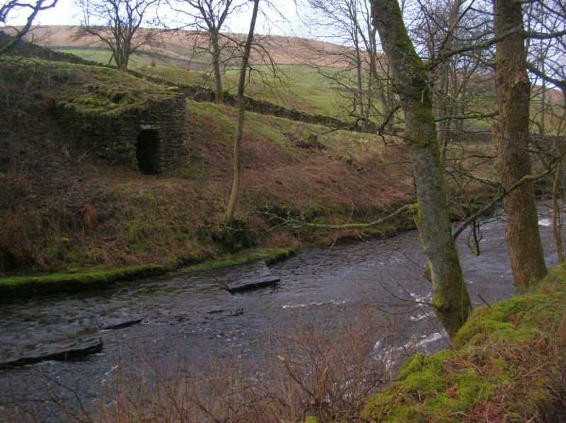
14/06/84 Lime Kiln built into hillside
approx. 50m south of Stonehouse
Bridge
GV II
Lime kiln, now disused. Probably earlier C19. Roughly coursed
sandstone rubble. Curved and battered sides, flat face;
barrel-shaped draw-hole opening with lintel slab.
INTERIOR filled in and top grassed over.
Good example of the type. Forms group with Stonehouse Bridge
(qv).
Listing NGR: SD7710185852
External links are from the relevant listing authority and, where applicable, Wikidata. Wikidata IDs may be related buildings as well as this specific building. If you want to add or update a link, you will need to do so by editing the Wikidata entry.


Other nearby listed buildings
