Approximate Location Map
Large Map »
Latitude: 51.0774 / 51°4'38"N
Longitude: -4.0602 / 4°3'36"W
OS Eastings: 255778
OS Northings: 132921
OS Grid: SS557329
Mapcode National: GBR KQ.DK7S
Mapcode Global: FRA 26D8.L1C
Plus Code: 9C3Q3WGQ+XW
Entry Name: Long Bridge
Listing Date: 19 January 1951
Grade: I
Source: Historic England
Source ID: 1384979
English Heritage Legacy ID: 485438
ID on this website: 101384979
Location: Barnstaple, North Devon, EX31
County: Devon
District: North Devon
Civil Parish: Barnstaple
Built-Up Area: Barnstaple
Traditional County: Devon
Lieutenancy Area (Ceremonial County): Devon
Church of England Parish: Sticklepath with Roundswell
Church of England Diocese: Exeter
Tagged with: Road bridge
This list entry was subject to a Minor Amendment on 20/03/2019
SS5532
684-1/4/1
BARNSTAPLE
Long Bridge
19/01/51
GV
I
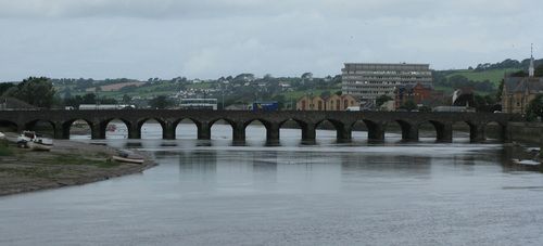
Road bridge over the River Taw, including causeways. C13 in origin except for the three arches on the town side, replaced in 1589 (Pevsner). Widened three times at least, once by James Green in 1834, most recently in the 1960s, using concrete faced with rubble. Grey rubble with ashlar arch rings to one of the later phases; rubble parapet. Approximately 159 metres long. Sixteen arches with the pointed medieval arches of the 3m (10 ft) wide original visible behind the later segmental arches; cutwaters; platband at road level; plain parapet.
This is an important medieval bridge on a very large scale.
Listing NGR: SS5577832921
External links are from the relevant listing authority and, where applicable, Wikidata. Wikidata IDs may be related buildings as well as this specific building. If you want to add or update a link, you will need to do so by editing the Wikidata entry.


Other nearby listed buildings
