Approximate Location Map
Large Map »
Latitude: 51.0791 / 51°4'44"N
Longitude: -4.0606 / 4°3'38"W
OS Eastings: 255750
OS Northings: 133109
OS Grid: SS557331
Mapcode National: GBR KQ.DC3W
Mapcode Global: FRA 26C8.KVY
Plus Code: 9C3Q3WHQ+MP
Entry Name: West View
Listing Date: 31 August 1988
Grade: II
Source: Historic England
Source ID: 1385374
English Heritage Legacy ID: 485836
ID on this website: 101385374
Location: Barnstaple, North Devon, EX31
County: Devon
District: North Devon
Civil Parish: Barnstaple
Built-Up Area: Barnstaple
Traditional County: Devon
Lieutenancy Area (Ceremonial County): Devon
Church of England Parish: Barnstaple St Peter and St Mary Magdalene
Church of England Diocese: Exeter
Tagged with: Building
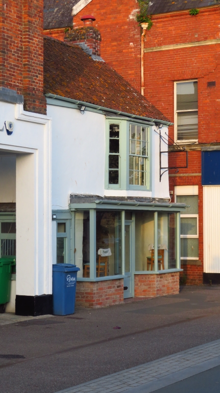
BARNSTAPLE
SS5533 THE STRAND
684-1/7/249 (North East side)
31/08/88 West View
GV II
House and shop. Probably C17 or earlier; possibly enlarged in
C18. Solid, roughcast walls, apparently of stone rubble. Roof
of front range slated; rear ranges pantiled. No chimney
visible from street. Plan consists of 3 single-depth ranges,
interior arrangmement considerably altered.
2 storeys. 1-window range, remodelled late C19 or early C20.
Shop windows in ground storey; canted bay window, off-centre
to right, in upper storey. Right-hand side wall (exposed to
side passage) has early or mid C19 sashes in middle range; an
8-paned sash in ground storey, 2 sashes with 4 full panes and
marginal quarter panes in upper storey.
INTERIOR: has few exposed features in ground storey: a heavy,
plain upper-floor beam in rear room, a fireplace with C19
marble surround and coloured patterned tiles in right-hand
rear corner of middle range. Upper floor and roof structure
not inspected.
HISTORICAL NOTE: old photographs show a chimney on right-hand
gable of front range. Front had 2 ordinary sash windows in
upper storey. Owner says his title deeds, dating back to
Charles II, describe the building as a former Customs House,
although John Wood's map of 1843 shows that a building a
little further south was then used for this purpose.
The modest scale of this building in a part of town much
rebuilt in C18 and C19, and the great thickness of the walls
separating the ranges, suggests that this is a building of C17
or earlier. It is likely to have features of interest
concealed under plaster, and possibly an early roof structure.
(Wood J: Map of Barnstaple: 1843-).
Listing NGR: SS5575033109
External links are from the relevant listing authority and, where applicable, Wikidata. Wikidata IDs may be related buildings as well as this specific building. If you want to add or update a link, you will need to do so by editing the Wikidata entry.


Other nearby listed buildings
